SpacePlace

Geography of cloud computing

The ever-growing need of relying on server infrastructure caused by cloud computing is an interesting recombination of space and technology. The Economist has a good piece about "where the cloud touches down", i.e. where to locate data centres and server farms. The fact that these facilities spring up in unexpected places such as old bunkers or shopping malls is an interesting indicator that their whereabouts is a serious concern and less an afterthought at it use to be.

"Now this haphazard landscape is becoming more centralised. Companies have been packing ever more machines into data centres, both to increase their computing capacity and to comply with new data-retention rules. (...) with demand for computing picking up in other parts of the world, the boom in data-centre construction is spreading to unexpected places. Microsoft is looking for a site in Siberia where its data can chill. Iceland has begun to market itself as a prime location for data centres, again for the cool climate, but also because of its abundant geothermal energy. (...) So will all data centres end up in remote places like Quincy or Iceland? Not necessarily. For many applications (...) firms want to have access to trading data in real time, which explains the high density of data centres near New York and London. And fast-moving online games must be hosted near their players."

As described in the article, the criteria that companies use to pick a site keep evolving. It's not only market economics but also local incentives (e.g. tax breaks). And we're heading to more complex recombination of technologies and space:

"In future the geography of the cloud is likely to get even more complex. “Virtualisation” technology already allows the software running on individual servers to be moved from one data centre to another, mainly for back-up reasons. One day soon, these “virtual machines” may migrate to wherever computing power is cheapest, or energy is greenest. Then computing will have become a true utility—and it will no longer be apt to talk of computing clouds, so much as of a computing atmosphere."

Why do I blog this? a sort of fascination towards the friction between the digital (allowed by such infrastructures) and the physical. In a way, this is a concrete example of how technologies physically reshape the material environment through new building typologies and new places colonized by technological facilities. This notion of "cloud computing" is intriguing as there is a clear paradox between the ethereal idea of a "cloud" and its very fixed geography.

Some sort of side urban computing issue that has lots of relevance anyway. Or perhaps given the remote location of some data center site, it's an example of "countryside computing"

Waiting and mirrors

Read in The Psychology of Waiting Lines by David Maister (1985):

"the example of ‘the well-known hotel group that received complaints from guests about excessive waiting times for elevators. After an analysis of how elevator service might be improved, it was suggested that mirrors be installed near where guests waited for elevators. The natural tendency of people to check their personal appearance substantially reduced complaints, although the actual wait for the elevators was unchanged."

(An example pointed by Sasser, W.E., J. Olsen, and D.D. Wyckoff (1979), Management of Service Operations: Text, Cases and Readings. New York: Allyn and Bacon) Why do I blog this? made me wondering about the affordances of space, the design of a particular place and how it can accommodate people's behavior.

The Globe as an entertainment platform

Two app that I like lately, for their entertaining potential: It's a bit old but I am still fascinated by this "If I dig a very deep hole, where will I end up?". It's a very basic google map app where you can choose to dig up somewhere and see where you go to arrive on the other side of the Earth:

"Are you concerned about where you go to arrive if you dig a very deep straight infinite hole on Earth? Your problems are solved! Surf on the map below, choose where you will dig your hole and click there. After this, click on "Dig here!" and you will see the place where, one day, you will (believe me) put your feet."

And of course, flickr vision is also compelling. It shows realtime, geolocated Flickr photos on that globe:

Why do I blog this? Those are fascinating and ludic spatial application that I find enjoyable, no more, no less. There are not perfect of course but they reflect some interesting aspects as well as intriguing motivations (following people's photo streams, digging the earth, etc.).

Graffiti removal selectivity

Seen in Lyon, France last week: removed

removed

Some graffitis removed, some other still there. How to establish a hierarchy of what should be removed? Is it the cost to remove big graffitis? the possibly-offensive content?

It gives an intriguing flavor of selectivity anyway. Stains are always curious as they are traces of activities and decisions taken by people.

How to kill an elephant path

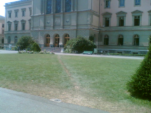
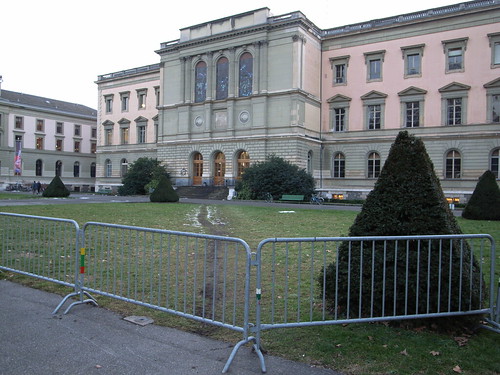
The last step of a neverending story (see previous episode here and when it all started). The tagline for this would be "how to kill a an unofficial route, a path that is formed in space by people making their own shortcuts“ July 2006: Elephant path in Geneva

February 2007: Please no

January 2008: dead elephant path

(the last picture shows the sign that say "please take care of the lawn, don't cross it please")

Why do I blog this? this is one of the most interesting aspect of urban life, how people's intents materialize ('desire lines' as one of the comment on my Flickr picture says) and how this is prevented by others forces. In this case, it's "to protect the lawn", which is a quite intriguing reason.

In addition, other things to think about: what's more efficient? the barriers or the warning sign? why isn't there any other elephant path starting on the other side (where there is no sign)? is it because you just get out of the building and it's acceptable to take a longer path?

Putting Space in Its Proper Place

Morning read in the train: "Toward a Geography of a World Without Maps: Lessons from Ptolemy and Postal Codes" by Michael R. Curry. In this paper, the author describes the implicit and widely accepted history of space:

"the world (and, indeed, the universe) was, once upon a time, seen as vast, too vast to be grasped in its entirety. While knowledge of the world was limited to knowledge of the local, the local was imagined as situated within this vastness. Through what might best be described as an evolutionary process, people gained an increasing knowledge of the local, of places, but began, too, to be able to situate those places within an increasingly comprehensible whole, which came to be called (but had always been) ‘‘space.’’ By the time of Ptolemy, a sophisticated—and familiar—geographical ontology had developed, wherein there was a hierarchy from place to region to space and wherein knowledge of places tended to be tinged with subjectivity, while that of space became increasingly amenable to more rigorous, mathematical understanding. On this view, the situation today, where geographic information systems, global positioning systems, remote surveillance systems, and related technologies are increasingly parts of everyday life, is continuous with that past, and is in a sense an expected step in that evolutionary process. "

And then shows us the flip side of the coin, describing how this is a "telic fantasy" using the postal code example:

"there are good reasons for believing that a more empirically grounded account of the relationship between the concepts of space and of place will indicate that that relationship has been, and remains, far more messy than on the ‘‘standard’’ account. (...) such an analysis will show that prior to the invention of written maps and lists, the means for the storage of information were far too feeble to underpin anything resembling the homogeneous and metrical idea of space that we find in, say, Ptolemy; ‘‘space’’ was, in fact, invented rather late in the day, in societies that offered the appropriate affordances. (...) People do not, on the whole, walk around with anything that could seriously be termed ‘‘maps’’ in their heads, and to attempt to resuscitate that idea by redefining maps as ‘‘sets of directions’’ (to take just one example) is to be dishonest."

Why do I blog this? I am more and more interested in human geography and the way they deal with space and the individual as it is far more interesting than what has been done in psychology recently. Furthermore, there are important conclusions to be drawn for ubiquitous/urban computing as it describes people's representation of space and place.

Curry, M. R. 2005: Toward a geography of a world without maps: lessons from Ptolemy and postal codes . Annals of the Association of American Geographers 95, 680-691

Urban warfare and its categorization of space

In "Slumlords: Aerospace Power in Urban Fights", Troy S. Thomas (Aerospace Power Journal, 2002) describes the challenging environment of future conflicts: urban warfare. Although I am definitely not into military research, the article is interesting because of its representation of space. Some quotes I found interesting:

"Understanding the urban setting is tough, given the complex and diverse nature of the environment. We need a framework that embraces the diversity of cities but in a manner that has actionable, operational significance (...) The urban system is unique in that it consists of five dimensions or spaces. First, the airspace above the ground is usable to aircraft and aerial munitions. Second, the supersurface space consists of structures above the ground that can be used for movement, maneuver, cover and concealment, and firing positions. For airmen, the supersurface warrants special consideration since the enemy can locate weapons such as surface-to-air missiles or antiaircraft artillery there. Structures also channel or restrict movement at the surface. Third, the surface space consists of exterior areas at ground level, including streets, alleys, open lots, parks, and so forth. Fourth, the subsurface or subterranean level consists of subsystems such as sewers, utility structures, and subways. (...) The fifth domain is the information space. (...) Distinctions between modern and primitive cities are a function of three subsystems: physical, functional, and social. All can exist in the five urban spaces. The physical subsystem consists of man-made terrain. (...) The physical and functional character of the urban battle space is irrelevant without the human dimension- the social subsystem, which includes a wide range of variables, such as culture, demographics, religion, and history. (...) rapid urbanization in developing countries results in a battle-space environment that is decreasingly knowable since it is increasingly unplanned. "

Why do I blog this? militaries (airmen in this case) have warfare doctrines that they use to derive strategies and tactics. As a matter of fact, doctrines rely on a vision of the future the try to project. In this article, what is interesting is how they deal with a representation of the urban environments of the future. The quote I picked up are a bit limited compared to what is described in the document, but I found interesting to read about this categorization of space, quite different from the one we often read in anthropology or ubicomp research about space&place.

Playful spaces in Geneva

playful space (2) playful space (1)

Why do I blog this? Two interesting examples of playful assemblage, definitely put together in some sort of informal urban setting. Of course they are hidden and a bit less accessible than city skate-parks and kids parks. They however prove to be intriguing in terms of their presence, showing the necessity to have playful area. What does that prove for urban computing? maybe nothing, perhaps the need to leave open spaces (even hidden) for creativity.

Space in Rio

Discovering new cities on continent where you've never been is always refreshing and intriguing. In Rio de Janeiro, I've tried to make few notes about spatiality. Nothing very professional (I'm not an urbanist) nor linked to my current research, it's rather my naive appraisal of space there. One of the first thing I've done there was to find a spot high enough to embrace the whole cityscape. It's definitely easier here since there lots of high-rise plus tourist spots such as the Corcovado or the Paõ de Açucar which allows to get views such as:

City structure (macro)

One can easily imagine on that picture how the city grew starting on the right and then spreading all over the place with only hills and the ocean as limits. Interestingly, there has been some attempts to fight against these boundaries: suppressing a hill on the right (where stands the cathedral), putting the material to extend the ground (and new beaches) or having informal buildings on hills (mostly favela areas).

The city appears to be very dense here but when you go to the south or much further from the ocean, it's then less high (still very dense) with favelas or low-rise buildings. Although streets and roads are quite big downtown, favelas do not have streets per se, it's rather corridors where no vehicle could get around (hence the presence of gang members who can secure their presence, less accessible to police forces). Rio is an interesting mix of very controlled urban planning (e.g. street grids very straights) and informal architectures (e.g. favelas).

At the street level, what struck me, especially in Ipanema, Copacobana, Leblon or Niteroi is the presence of a structure almost always based on the model below:

Space (micro)

In a sense: street level have either shops or buildings with fences. Generally there are even two fences with digicodes and very often a guardian/janitor. No one seems to live at this level and the first story is also generally very high from the street. As a European, this gives the impression of living far enough from the street level: a sort of Ballardian architecture of control. In a way it's close to what Mike Davis would describe at the city level in LA (Bunker Hill separated form the rest of the city) except that here it's at a micro level: every building seems to maintain a certain distance between appartments and the street. Again, this is entirely different from old colonial one/two-stories buildings or favelas in which appartments spread everywhere there is enough room to put a blanket/mattress.

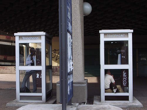
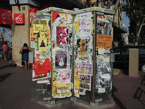
Phone booths variety

The richness of phone booths Oï! (Paraty, Brazil)

Phone booth (Amsterdam, Netherlands)

2 booths (Lyon, France)

Phone booths (Marseille, France)

Please note the different conception of privacy (bubble, box) or how parts of the booth are used in other way (broken glass to seat, to attach a bike, to put ads). What does that say about space? urban computing?

The necessity of green

Perhaps that's the 2007 trend I find the most important (since we now are in 2008 and can look retrospectively): the grass was green (Rio de Janeiro, Brazil)

A patch of green (Geneva, Switzerland)

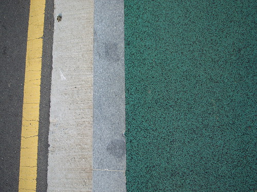
Interesting pavement (Seoul, South Korea)

"the grass was green" (Lyon, France)

All these encounters with fake grass in different parts of the world (over the last year) always make me smile and think about how our relationship to nature is important, awkward and controversial. "Green coverage" appears to be the most ridiculous way to convey a sense of nature, showing how it's important for human to still be close to it in contemporary cities. What does that say about urban informatics/computing? There is really a need to be closer to Nature but the proposed solution in these examples is flawed from the beginning.

Urban informatics

Adam has an interesting query/blogpost about "what do you feel are the most significant contemporary developments in urban informatics? The most resonant projects, the most powerful interventions, the scariest precedents?". That's quite an important question that I try to ask myself for a while. Since I have not definite answer, I tried to pick up some examples I find relevant to get a messy list of "urban computing" projects:

  • Location-based services: be they single-user (navigational devices such as personal GPS navigator) and ones who can have a social layer (see DASH for instance) but also mobile social software
  • Urban screens and interactive billboards (see more about this here).... that can display representations which allow to make explicit invisible or implicit phenomena: blogging pigeon, Real Time Rome (among other Senseable City projects), AIR, undersound or Tripwire, etc.)
  • open mapping projects (like open street map) and other geospatial web applications (see Jo Walsh's stuff, especially here piece about MUDlondon) a la place-based annotations (Urban tapestries among lots of others).
  • Geographical Information Systems (./ although there would be a lot to say about this)
  • pervasive games (no list about this here but you know what I am talking about)
  • Identification systems such as these RFID cards you now have in most occidental cities in subways.
  • Defensive Space can also be supported by technologies: not only CCTV, Vsee for example the mosquito sounds to avoid teenagers loitering
  • Lazarus/zombie devices
  • infrastructures can also count: think about wiring, server farms or gigantic telecom hotels.

But of course, it's a bit awkward to limit oneself to purely urban/contextualized projects: a cell phone, web mash-ups, Twitter or whistles might well count too.

This is really non-exhaustive and raw list, there are multiple points of entries that can be used to go beyond this: technologies (RFID, GPS...), the number of users (single-user, multi-users), the role (navigation, entertainment), the nature of content (delivered by an institution, user-generated, sensor-captured), the context of the project (product, services, art piece), etc. Well, that's a starting point for now.

Then, the next question that I particularly interested in is not the projects but the activity of people in contemporary cities (as you may have noticed in this blog): people putting stickers on the streets, fake grass, crocheted stuff on signs, fake heart stickers on traffic lights, etc.

City legibility and ambient informatics

Reading "City of Bits: Space, Place, and the Infobahn" (William J. Mitchell) during the holidays, I ran across that quote:

"we are beginning to know and use cities in new ways. Long ago, the urban theorist Kevin Lynch pointed out the fundamental relationship between human cognition and urban form - the importance of the learned mental maps that knowledgeable locals carry about inside their skulls. These mental maps, together with the landmarks and edges that provide orientation within the urban fabric, are what make a city seem familiar and comprehensible. But for us artificially intelligent cyborgs, the ability to navigate through the streets and gain access to city resources isn't all in our heads. Increasingly we rely on our electronic extensions - smart vehicles and hand-held devices, together with the invisible landmarks provided by electronic positioning - to orient us in the urban fabric, to capture and process knowledge of our surroundings, and to get us where we want to go."

Why do I blog this? Except the "cyborg/intelligent" rhetoric that I don't parse and acknowledge, that quote is quite interesting and it echoes with recent readings such as what Greenfield and Shepard describes in "Urban Computing and Its Discontents" or the work of Anthony Townsend that I mentioned the other day. This is interesting as I am interested in how urban computing (will) affect cities, especially how location-aware applications or networked objects would change city life (the "user experience" of city sounds pretty lame here).

The link between Lynch's work about the legibility of cities and urban computing is of great interest to me as it resonates with my background in cognitive sciences. To some extent, it boils down to this simple question: "how people take decisions about what they do in an urban environment?": how do people navigate through streets and avenues, how do they choose specific points of interest, how do they change their path, etc. Kevin Lynch provided some answers about this, showing how mental representation of space is built based on urban elements such as paths, edges, districts, nodes, and landmarks. For instance, he showed how specific angles of elements in a city allow for easier way-finding, or how people position their head and body in relation to their environment in navigation determine their navigation. The reason why this is interesting is that Lynch's work is a bit less mentalist as the dominant model in cognitive sciences: people's decision can be based both on mental representation (very cognitive) AND situated elements of space (less cognitive). On top of that, you can add the fact that mental maps can be built upon situated elements...

Anyway, back to Mitchell's quote, electronic flows of information and representation can modify and affect the decision process I just described. However, I am still missing elements about this, more detailed accounts of the interlinkages between cognition/urban forms and urban computing.

"-Ware"

"Urban Computing" is defined by Kingberg, Chalmers and Paulos as "the integration of computing, sensing, and actuation technologies into everyday urban settings and lifestyles". Ware

That picture taken last week in Geneva appears to me as strikingly evocative of "urban computing". The suffix "-ware" added on top of a physical layer indeed reflects how urban computing is not just about digital bits but also raw, messy and dirty material in the city of the near future. That said, it's also interesting as the suffix "-ware" is used in a large variety of forms, sometimes without any reference to its origin (manufactured article of a specified type, made with particular substance).

Burglar vocabulary: location-based tagging

Last week in Brussels, I ran across this signs on the wall of that house: 165+ tagging

It quickly reminded me my parents' house on which we found the same marks. At that time, I remember the discussion with local police who told us that burglars use codes to annotate house. It's generally tags like this, with black chalk that express relevant information for them such as the one exemplified below (as shown in France's signs or Belgium's signs).

Simply put, it means that the marks on that belgian house correspond to: one kid, unoccupied house and planned robbery. Although it's weird to imagine only one kid in an unoccupied house, this is what the tag describe.

Why do I blog this? that's an interesting example of location-based annotation. It simply shows an intriguing signal of practices at stake in contemporary cities, a specific form of graffiti that aims at describing places to rob. It's a different form of spatial tagging not that explored by the locative media frenziness (for obvious reasons) that also represents the "transparent society" we're reaching. See here too.

In addition, it's curious from a collaboration POV, how this sort of tagging has been put in place by a group of people. At first glance, one can think burglary is a competitive practice, but it can go beyond that, as shown by the establishment of a common vocabulary.

Protecting one's electricity

Different ways to protect one's source of electricity: Well covered in a french train: Protected source of electricity

With duct tape at the airport in Brussels: Locked electricity

Why do I blog this? in a time where we have our pockets full of mobile devices that require electricity, it's always an issue to find a power plug. This is even more important when you hang out in Marc Augé's "non-places". Most of time, it's in these areas that owners of the infrastructures are trying to design different ways to prevent you from accessing it. Even when there are still plugs for vacuum cleaners or christmas trees, there are always some possibilities to show you that you're not welcome to steal a bit of volts.

Increasing pace of interactions in our cities

In Life in the Real-time City: Mobile Telephones and Urban Metabolism, Anthony Townsend deals with the implications of new mobile communication on contemporary urbanization. Unlike preceding technologies such as automobiles or telephones, Townser argues that mobile phones may not results in "enormous physical upheavals" (such as suburbian low-rises or CBD skyscrapers). What may happen is rather that mobile communication may rewrite the rules of spatial/temporal communication turning decision-making in everyday life as something more complex and less predictable. This will eventually lead to more decentralization, more interactions... which will "speed the metabolism of urban systems" with more "activity and productivity". Hence a situation where we have a "real-time city in which system conditions can be monitored and reacted to instantaneously". What are the consequences of this situation according to Townsend? Some excerpts:

"Mobile communications technologies reinforce the competitive advantage of central city business districts by making them more efficient, yet at the same time make megalopolitan automobile-based urban sprawl manageable and livable. This dramatically complicates emerging internal conflicts within the field of city planning on issues such as New Urbanism and urban sprawl by undermining the existing technological space-time regimes that have both driven the trends and framed debate.

Second, and far more importantly, massive decentralization of control and coordination of urban activities threatens the very foundations of city planning – a profession based upon the notion that technicians operating from a centralized agency can make the best decisions on resource allocation and management and act upon these decisions on a citywide basis. "

Why do I blog this? Townsend's idea of the "intensification of interactions" as a consequence of mobile communication is interesting, and different form people who keeps advocating for a so-called "end of space/world is flat" motto. While some people are trying to find the material impacts of mobile phones on cities (new building forms, etc.), his insistence on a qualitative influence is interesting.

What is then pertinent in this paper is Townsend's proposal for urbanists to go beyond classical tools ("the widespread bit-by-bit reconstruction of cities is going largely unnoticed by planners accustomed to visualizing cities through aerial photographs"). Classical tools are also problematic because of their centralized perspective approach, which will prevent urbanists to grasp the ever-increasing changes of city metabolism. Therefore, there is a need for new paradigms in urban planning such as more complex models of swarm intelligence (he mentions StarLogo but there might lots of other and more advanced models).

Bottom-up innovation and velo'v

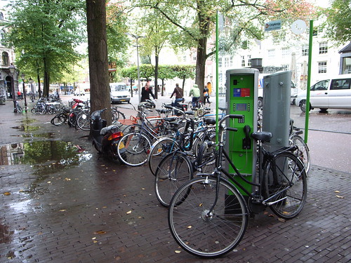
In this post, I mentioned this bike rental service called velo'v in Lyon (Paris has velib, Brussels has cyclocity, etc.). They're managed by JCDecaux and you can read Re*Move for an analysis of this. What is interesting is to observe the side practices around these bikes. Two examples: Look how here the saddle is rotated, which is a trick used by people to show that the bike does not work well (or a part is broken): Velo'v trick

In the second example, a part of the bike has been painted in pink by ACTUP activitists (in paris they covered saddle with pink tissue): Pink velov

Why do I blog this? going through some pictures I've taken recently, look at emerging patterns, observe what that means for urban computing. In these cases, it's the "bottom-up innovation" aspect that I find intriguing and how the infrastructure that has been put in place by JCDecaux is apprehended, the creativity around it and what this means to rethink these artifacts in the city of the near future.

Certainly, material for a talk concerning "bottom-up innovation and urban computing"

A framework of "place" for LBS design

Morning read in the train this morning was "A Framework of Place as a Tool for Designing Location-Based Applications" by Anna Vallgarda. The paper is about a "framework of place" defined through interviews with architects, that aims at informing the development of location-based applications. The author describes what are the structure and properties of place that are important for architects as potentially influencing the conception of "how human beings perceive their presence in place". The point is that developing applications based on context require the knowledge and meaning of the significant parameters of the place where it should work. That's why she reviews different "location models" (aura model, nexus model, etc). TRying to summarize the framework she describes lead me to:

"To recapitulate, the concept of place refers to the physical order of objects; it is the physical boundaries within which we act. This framework is an account of what such boundaries contain (and their potential attributes).

Atmosphere: Light: northern, southern, artificial or strong/weak or direct/indirect Color: cold/warm or strong/pale or red, yellow, blue Materials: concrete, tree, glass, stone, clay, tile or rough/soft Proportions: human scale or large industry building Shape: circular, square, blurred Vertical position: floor or altitude Temperature: Celsius or Fahrenheit Air/wind: clean air or wind speed Sound: machine, animal, human or high/low

Activities: Entrances: bodily, visual, audible or mediated/direct or easy/difficult Functionality: bathroom, kitchen, playground Resources: power, water, gas, WiFi

Hierarchies: Social: home – community garden – town-hall square (enables social navigation) Proportion: house – apartment building – industrial area (enables physical/social navigation) Indoor/Outdoor; bed room – balcony – plaza (enables physical/social navigation)

Infrastructures: Type Modalities Measures Enables Bodily: foot, car etc. (measure: meters, miles) (enables movement, overview, social interactions) Visual: direct, mediated (measure: clarity) (enables: visual contact, overview, social interactions) Audible: direct, mediated (measure: decibel) (enables: audible contact, social interactions) Material: water, power etc. (measure: liters, voltage) (enables: various activities)"

Why do I blog this? as I am interested in the UX of location-based application, this sort of framework is interesting as it aims at "establishing a more nuanced notion of location", which is often a problem (as location is often limited to a dot on a map without any thoughts about granularity or contextual problems). As the author mentions,it would be good to complement it with environmental psychology, cultural geography, and anthropology.

It's also limited to indoor locations, I may find interesting to repeat this work and complement the model at the city level, with urban planners or transport/infrastructure practitioners for example.