Working lately on visualization of coordinating agents, I ran across old work about cyberspace visualization that struck me as very intriguing. See for instance Cyberspace geography visualization: Mapping the World-Wide Web to help people find their way in cyberspace by Luc Girardin (bro of fabien).
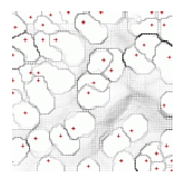
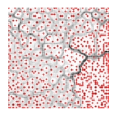
The central goal of this paper is to give information about virtual locations to the actors of cyberspace in order to help them solve orientation issues, i.e. the lost-in-cyberspace syndrome. The approach taken involves low dimensional digital media to create the visualization that can guide you. (...) To perform this task, the self-organizing maps algorithm is used because it preserves the topological relationships of the original space, conjointly lowering the dimensionality. (...) By geometrically approximating the vector distribution in the neurons of the self-organizing maps, this method provides a means to analyse the landscape of the mapping of cyberspace.
Here are maps of three websites:
Why do I blog this? The aim and the viz are interesting. At that time, there was this navigational issue of how people would navigate in the hypertextual virtual world. Now things changed a bit actually and it seems to me that the hypertext has been either forgotten or taken for granted (well the wikipedia is a cool hypertext isn't it?). More here