Trying to expand on what fabien blogged (weblog as a way to elaborate our thoughts), I am digging the internets to find how digital information/traces/logs can be mined and of interest. The massive number of traces generated automatically (cell phone, wifi laptops) or by the user (synchronously or asynchronously with flickr pictures) can be used to perform inferences about spatio-temporal of city inhabitants. Fabien describes 3 main domains of applicability of the processing and visualization of these massively collected personal logs, traces: 1) Provide urban planners, transport authorities and traffic engineers with data to refine their models of citizens spatio-temporal behaviors. 2) Bring new perspective for decision making and policies building. 3) Raise awareness and effect the discussion making of individuals or of a crowd
 (Picture: mapping by Fabien of Flickr images taken in San Francisco between March 11 and March 25, 2007)
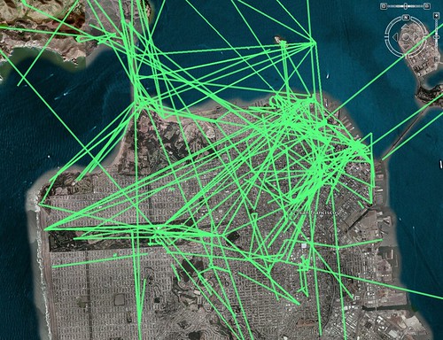
Why do I blog this? IMO, beyond a representation of the digital layer, there is another level, that would be: how to use the data generated by people (cell phones call/sms, flickr pictures at certain location, lbs patterns, games...) to have a sort-of "infrastructure" that would allow to specific services. For example: is it possible to design a public transport information system relying on these information?
This topic is also addressed in the following paper: Ratti C., Pulselli R. M., Williams S., Frenchman D., 2005,"Mobile Landscapes", Environment and Planning B - Planning and Design. Some excerpts:
"A possible study would be to use this data to infer information about the ‘character’ of a neighborhood where the antenna is placed. At a simplistic level, districts with base stations showing a prevailing use during working hours are likely to have an office/business nature. Neighborhoods with high evening and early morning cell phone traffic are likely to have a stronger residential character. On the other hand, residential neighborhoods with high cell phone use during business hours may reveal emerging live-work situations. (...) our hypothesis is that the patterns of cell phone intensity correlate with the intensity of urban activity; revealing them can help monitor important urban dynamics. Critical points in the use of the urban infrastructure can be highlighted, as well as special events. Finally, a long-standing problem can be addressed: that of estimating flows in and out of the city: patterns of daily commuting, weekday versus weekend activities, holiday movements. Real time applications could also have new uses in emergency relief, based on broadcast alerts that would be different from one region to the other.
As the authors say, this seems to be a "new promising line of urban research: Making sense of the unlimited flow of data from the cell phone infrastructure in the urban context is still unexplored territory". Even though the article focuses on data gathered through cell phones, I think the situation is similar with all the digital information generated by ubicomp systems and social web applications (a la flickr).