Locative Media

Tech Report about designing multi-user location-aware applications

A recent EPFL Technical report I wrote with Fabien Girardin and Pierre Dillenbourg: A Descriptive Framework to Design for Mutual Location-Awareness in Ubiquitous Computing.

"The following paper provides developers, designers and researchers of location-aware applications with a descriptive framework of applications that convey Mutual Location-Awareness. These applications rely on ubiquitous computing systems to inform people on the whereabouts of significant others. The framework describes this as a 3 steps process made of a capturing, retrieval and delivery phase. For each of these phases, it presents the implications for the users in terms of interpretations of the information. Such framework is intended to both set the design space and research questions to be answered in the field of social location-aware applications."

The paper actually gives an overview of the main issues regarding location-based services, and more specifically multi-user location-aware applications/mobile social software.

Location-based annotation

Water overflow A location-based annotation that indicates when water overflowed that street in paris. Interesting marker of the past (from 1910) that aims at reminding a different state of the environment. That's the sort of Holy Grail for mobile phone service developers... who try to promote a digital equivalent to this. Where are we in 2008 wrt to this sort of system?

User Experience of TomTom

Jan Borcher's "ode to TomTom" in the last issue of ACM interactions addresses issues that are relevant to my interest in the user experience of location-based applications. First about usability issues of TomTom:

"City or street names are listed so close below each other that you keep selecting wrong ones—Fitts' law at work. I also got a furious call when my sweetheart first tried using it: Köln (Cologne) wasn't in the city list. It turned out TomTom had left out German umlauts from their onscreen keyboards (...) Oh, and turning it on is a nightmare. Pressing the tiny, half-sunken power button briefly is happily ignored, but keep pressing it a couple times at the wrong moment and it won't turn on at all."

Second, about weird features:

" Feature development doesn't stop at its sweet spot. Beyond the idea of providing reliable, easy-to-use directions, TomTom has since added an MP3 player, live updates through the wireless network, connections to "Buddies" (the use of which has escaped me so far), cooperative street updates, photo slide shows (I'm not kidding), and a stream of other features. Some of these are actually useful, but the original TomTom was the sweet spot"

... which he relies on to discuss the latest phase of product development which is a "baroque" step that "obeys the terrible law of feature creep". The new feature, instead of having a user value, make life more complex... and eventually makes it difficult to use the device in its first and intended use. Why do I blog this? Some interesting discussion about product development and evolution towards complexity (most definitely due to forces that aim at renewing products very often).

CACM on location-awareness and location-tracking

The last issue of Communications of the ACM featured an article about location-based services that deals with user perceptions of location-tracking and location-awareness services. Some excerpts I find interesting here: First, about the slow adoption of these technologies:

"Generally, the slow adoption of LBS has been explained primarily by three causes. First, the implementation of more accurate localization techniques (such as E-OTD, U-TDOA, or A-GPS) through providers has taken longer and has been more costly than expected. Second, the few available LBS applications display long response times, often too long for users to handle. And third, users are concerned about privacy issues that are an inevitable side effect of LBS. "

I found interesting the framing in the article in terms of "humans" and "non-humans" although it's not referring to Latour's work: "one of the entities, whether human or non-human, is always the object of LBS, that is, it is the entity about which location information is recorded". The authors also make the distinction between location-aware systems and location-tracking services:

"Location-tracking services provide information about a user's whereabouts to entities other than the user, while location-aware services supply the user (the information requester) with personal location data. In the case of location-aware services, the location-information- causing entity is the recipient, whereas for location-tracking services, an external third party requests and receives location information about another entity. A car navigation system is a location-aware service. Here, location information is provided to the requester (the driver) who, in return, receives real-time navigational services. Other examples of location-aware services include location-sensitive billing (paying while passing toll stations), and location-specific store advertisements sent to a consumer's mobile phone when the person is in proximity."

In their lab experiments, the authors found that people found location-tracking capabilities more useful than location-aware services. Why do I blog this? the situation concerning LBS seems to be the same as time unfold, the same questions as the one discussed in the last 5 years are still unsolved (privacy is and will always be a problem. Things discussed in this paper echoes a lot with my ETech 2008 presentation.

My talk at O'Reilly ETech 2008

Yesterday I gave a talk at ETech 2008 entitled "Mobile Social Software from the inside out", which was an updated version of my overview of the issues (and some solutions) regarding multi-user location-based applications. People interested in the slides can have a look at the annotated version I've put here (pdf, 14.5Mb). The reason why I gave an existing talk was that I've never presented that one in the US (only in European countries and South Korea) and was curious of the reactions. O'Reilly Emerging Technology Conference 2008

CACM about "urban sensing"

Urban sensing: out of the woods is a paper by Dana Cuff, Mark Hansen, Jerry Kang that deals with embedded networked sensing that successfully shifted from the lab to the environment. Some excerpts I found interesting:

"urban sensing shifts focus and control away from the scientist at the center. We can anticipate new forms of science built from large-scale citizen-initiated data collection. Data will also be collected, then interpreted, in ad hoc ways by everyday citizens going about their daily lives. (...) There are at least two concerns: bad data processing and the "observer effect." First, when amateurs collect data through cheap, unverified, uncalibrated sensors, the immediate fear is "junk data." (...) Second, observation generally and surveillance specifically alters human behavior. (...) The data commons and citizen-initiated sensing will provide answers, pose new questions, and open new opportunities for public discourse.(...) urban sensing has the potential to generate a "data commons." By this, we mean a data repository generated through decentralized collection, shared freely, and amenable to distributed sense-making not only for the pursuit of science but also advocacy, art, play, and politics. (...) Today's exotic and disturbing data collection practices may appear banal 10 years hence. To the extent that privacy preferences are adaptive to the environment in this manner, we must be aware that today's policy choices will have long-term path-dependent effects."

Why do I blog this? some interesting issues regarding urban sensing. I am personally interested in how they can be used, how these networked objects can create new applications in the city of the near future. As I blogged the other day, is it useful for urban planners? architects? city dwellers? Can we design intriguing services or playful environment based on them?

Cuff, D., Hansen M., & Kang, J. (2008). Urban sensing: out of the woods. Communications of the ACM, 51(3), pp. 24-33.

Etech 2008: Tom Coates about Fireeagle

Tom Coates announced the launching of a geo-service called Fire eagle. 3 ideas behind the scene that informed this project: - we should build services that cam manifest everywhere the network touches - the back-end of ubicomp. - in this new world we're creating, the service should stay in a silo but they should play well with others. - decouple the creation and use of data: one service to create data, another one to use them.

These 3 things are particularly important in the domain of location-based services most of existing LBS are falling into one of these 2 categories: getting location / using location. Very restrictive. A better model: get location on one side and then other services for using location. But we can go past that: if any service in the world you inform any service.

Fire eagle: allows you to share your locations with other sites and services safely through a secure server. Fire Eagle keeps only the most recent piece of location information it has received. It helps you to share your location online as you want, control your data and privacy, easily build location services.

From the user perspective, very trivial, you go and set your location (text, GPS coordinates...) and you can connect with other applications such as Dopplr. And Dopplr can update your fireagle location depending on where you plan to be (the service provided by Dopplr)

Fire eagle is close to the idea of "Spimes", object that represents themselves in space and time.

In a panel at the Mobile City conference

Participated in a panel yesterday as the Mobile City conference in Rotterdam. The event was great and fully packed with a nice program and audience. The conference was a multidisciplinary even about locative media/mobile technologies and their relation to the City. The panel was about “Designing for Mobile Media & Urban Spaces: between Theory and Practice” and addressed challenges and opportunities of the field, as well as the link between theory and practice. Although my panel-colleagues were speaking at high level socio-politic theory, my point was to focus on issues regarding interaction design and spatial environment (not that I dismiss the privacy issues of locative media or the politics of ubicomp but it's not my field).

My point was to describe one of the limit of current location-based services design: the fact that most of the time space (the material environment) is assumed to be uniform and homogeneous. Based on the work we did in the CatchBob! project (a location-based gamed developed to be played on our campus), as well as some other material, I described how this was not the case. The organizers asked us to bring 3 pictures to exemplify this. These 3 issues/pictures are not exhaustive of course.

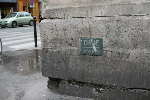
My first point was about the roughness of the environment: the world have flaws, breakdown, accidents, things are being repaired or regulations make systems more complicated. And because of that, users of location-based applications are sometimes lost, frustrated or clueless about what is happening on their screen. In our tests, we had some users who felt lost on our campus (where they have been studied for 3 years!). So the environment is dynamic and conditions change (not to mention the weather that could influence the positioning accuracy or the topography).

(Picture courtesy of Patrick Jermann)

The second point concerned the heterogeneity of space. The picture shows the mapping of WiFi antennas or our campus. As one can see, they are not evenly distributed and since we used Wireless signals to compute people's location in space, it was clear that the accuracy was different depending on the location in space (it was less accurate in the lower part). In addition, the heterogeneity of space is also caused by topographical limits: indoor/outdoor transitions for example.

(Picture courtesy of Fabien Girardin)

And finally, that picture shows three different traces of a passage in space using a GPS. Depending on the level considered, the accuracy of the positioning is way different (from dots to a straight line). Sometimes it's not even continuous, so how can we design a service based on that?

Down the road, my point was to show through these 3 examples that there are limits to the continuity of the user experience. All the components of the locative media ecosystem are complex and they can either be taken as limits or as opportunities.

Thanks Michiel and Martijn for the invitation. I'll try to put my (long) notes later on.

About tracking pizza's location

(via)Read in Information Week:

"At an 11-store chain of Papa John's restaurants in north Alabama, location data is being pushed directly to customers. Using an online-tracking system developed by startup TrackMyPizza, customers can watch online as their deliveries move street by street toward their doors. Drivers carry GPS-enabled handsets that feed location data to a TrackMyPizza server. There, the data is coupled with the customer's phone number, providing location updates every 15 seconds. (...) Sound like technology overkill, just to know your pizza hasn't gone astray? Rival Domino's thinks consumers want more such information about their orders, and it's doing a national rollout of a Web system that shows buyers when their pizzas have been prepared, cooked, then sent out the door. But it doesn't offer location once the pizza leaves the store. (...) At Papa John's, pizza tracking is delivering business benefits in its first two months by getting more people ordering online--a 100% jump in online ordering since the rollout, says Tom Van Landingham, the franchise operating partner. Online orders save phone-answering time, and Web customers spend about $2 more per order, since they can see the whole menu. About 18% of all delivery customers in the last 60 days have gone on the Web site to track their pizza. Van Landingham expects to begin using the tracking system to improve productivity behind the scenes, by plotting more efficient delivery routes, for instance. The service is only 2 months old, so it still needs to prove it's more than a novelty. But the chain proved it can be done."

Why do I blog this? The perspective of having people at home riveted to their computers, following the movement of their pizza mapped digitally makes me giggle. It looks like a weird version of Pacman where you don't have any control on your little character. Perhaps there is something cultural that I am missing or maybe it's the novelty who made people following their pizza on-line.

So, at first glance, this looks awkward and I am really curious to see if there are some user experience researcher already doing work on this kind of service. Beyond people's motivation to track an artifact that may be in their stomach one hour later, it would be interesting to understand more what are the expectations towards the pizza's location, the sort of happenstance people fear about this or even the reactions they would have if the pizza wandered around instead of taking a straight line to the consumer's house. To some extent, this is a PERFECT tool to conduct psychological experiments!

Disney location-based services on Nintendo DS.

Wired reports on this intriguing modified Nintendo DS called "Disney Magic Connection" that offers location-based services (navigation, where to find what...). But it seems that it was not so much of a success.

Interestingly, Jim Hill describes what went wrong:

"The problem wasn't with the technology. From what I hear, aside from a few minor GPS & battery-related issues, the "Disney Magic Connection" units worked great. (...) the Imagineers had originally hoped that they'd be able to recruit upwards of 60 families to take part in each day's field test. But on most days, WDI had to settle for less than half that number. Mostly because cast members had such a tough time convincing families to come try "Disney Magic Connection." (...) ost people have already invested an hour of their precious vacation time just in getting to the entrance of the Magic Kingdom. And to finally make it through the turnstiles and really be looking forward to that first ride ... And then have some clown with a clipboard accost you, asking you if you'd be interested in taking part in some pilot program, was more than most parents with small children could bear at that moment. (...) Another aspect of the "Disney Magic Connection" field test that allegedly turned off a lot of would-be participants was the security deposit. You see, before these folks could actually get their hands on that DS, they were asked for a credit card. Which Mickey then took an imprint of. So that -- in the event that these Magic Kingdom visitors accidentally left the theme park without first returning their test unit -- Mouse House officials could then charge them $300 for the missing device. (...) Another cost-effective aspect of the "Disney Magic Connection" project is that these handheld units actually make use of the 400+ sensors that were put in place in this theme park back in 2004 for the "Pal Mickey" project. Of course, because there were areas in the Magic Kingdom where WDI deliberately didn't put sensors (So that this interactive plush then wouldn't speak up and ruin the show for all of the other guests) ... The Imagineers had to install hundreds of additional sensors so that these Nintendo DS units would then tell the guests where they were. (...) And -- yes -- I did say "rent." As of right now, the Walt Disney Company has no plans to sell these handheld units. Nor will you be able to bring your own Nintendo DS into the park from home and then tap into Disney's wireless network."

Why do I blog this? because it's a marvellous story of a technological failure. The service looks okay, the technology's there but there are lots of user and contextual issues that lead to this situation. Even the platform (Nintendo DS) is interesting but there's always more hidden below the technological/interface's structure.

GPS bottles and people representation of space

"Message in a Bottle" is an intriguing locative media art project by Layla Curtis:

"Fifty bottles containing messages were released into the sea off the south-east coast of England near Ramsgate Maritime Museum, Kent. The intended destination of the bottles is The Chatham Islands in the South Pacific Ocean. The islands, which are 800km east of mainland New Zealand, are the nearest inhabited land to the precise location on the opposite side of the world to Ramsgate Maritime Museum. It is anticipated that the bottles may be found several times before reaching the Chatham Islands. (...) Several of the bottles are being tracked using GPS technology and are programmed to send their longitude and latitude coordinates back to Ramsgate every hour. The information they transmit is used to create a real time drawing of their progress."

People who found a message could report it (and then replace the bottle's contents, reseal the bottle and release it back into the sea to continue its journey to The Chatham Islands).

Why do I blog this? Beyond the poetic/aesthetic aspects of the lost bottles, I find this project interesting as it explores other use of GPS, related to the movement of objects in space.

Furtermore, an interview of Layla Curtis by Peter Hall in the Else/Where mapping book interestingly address some topics that are close to my research interests. Hall highlight the fact that "there's a nice juxtaposition here between the precision of the GPS mapping system and the relative imprecisions of people reporting findings by email". Of course, this is partly caused by the interface Curtis provided to report bottle's findings; as people had to fill a form with "Place bottle found". It can be very relevant to dig more into the naming of these places; I can imagine a sort of typology of mismatch that would be very informative for location-based services designers.

A framework of "place" for LBS design

Morning read in the train this morning was "A Framework of Place as a Tool for Designing Location-Based Applications" by Anna Vallgarda. The paper is about a "framework of place" defined through interviews with architects, that aims at informing the development of location-based applications. The author describes what are the structure and properties of place that are important for architects as potentially influencing the conception of "how human beings perceive their presence in place". The point is that developing applications based on context require the knowledge and meaning of the significant parameters of the place where it should work. That's why she reviews different "location models" (aura model, nexus model, etc). TRying to summarize the framework she describes lead me to:

"To recapitulate, the concept of place refers to the physical order of objects; it is the physical boundaries within which we act. This framework is an account of what such boundaries contain (and their potential attributes).

Atmosphere: Light: northern, southern, artificial or strong/weak or direct/indirect Color: cold/warm or strong/pale or red, yellow, blue Materials: concrete, tree, glass, stone, clay, tile or rough/soft Proportions: human scale or large industry building Shape: circular, square, blurred Vertical position: floor or altitude Temperature: Celsius or Fahrenheit Air/wind: clean air or wind speed Sound: machine, animal, human or high/low

Activities: Entrances: bodily, visual, audible or mediated/direct or easy/difficult Functionality: bathroom, kitchen, playground Resources: power, water, gas, WiFi

Hierarchies: Social: home – community garden – town-hall square (enables social navigation) Proportion: house – apartment building – industrial area (enables physical/social navigation) Indoor/Outdoor; bed room – balcony – plaza (enables physical/social navigation)

Infrastructures: Type Modalities Measures Enables Bodily: foot, car etc. (measure: meters, miles) (enables movement, overview, social interactions) Visual: direct, mediated (measure: clarity) (enables: visual contact, overview, social interactions) Audible: direct, mediated (measure: decibel) (enables: audible contact, social interactions) Material: water, power etc. (measure: liters, voltage) (enables: various activities)"

Why do I blog this? as I am interested in the UX of location-based application, this sort of framework is interesting as it aims at "establishing a more nuanced notion of location", which is often a problem (as location is often limited to a dot on a map without any thoughts about granularity or contextual problems). As the author mentions,it would be good to complement it with environmental psychology, cultural geography, and anthropology.

It's also limited to indoor locations, I may find interesting to repeat this work and complement the model at the city level, with urban planners or transport/infrastructure practitioners for example.

Talk at Google about location-awareness

Been at Google Office in Zürich this afternoon for a Tech Talk about "location awareness and mobile social computing". Google's R&D office in Zürich is actually very well into maps and spatial applications, which is why I wanted to confront my ideas to them. Although this is my usual talk about barriers and problems of location-aware applications, the version is evolving constantly since I started presenting it. See here for the slides. I try to take into account people's comments and the things we discuss are a lot different depending to whom I present it to. Google office in Zurich

The discussion revolved around notions such as:

"- are there different perception of storing personal data such as location, how do people accept that? know that their location is stored? - are there different cultural or behavioral reactions depending on countries, wrt usage of location-aware devices - people found interesting the fact that the location-aware application which seems the most successful is not really a location-aware system as it is Jaiku. We had a discussion about how I found this platform relevant as it can allow people to disclose the information they want (and to show others how and where they want to look like). - if the mobile phone is a bad platform, what about navigation devices such as TomTm or GPS artifact, can they be a solution to reach a critical mass (interestingly the same point that was brought forward at Cisco the other day). - what about the ecology of interface: is-it only about mobile location-awareness? can we use other outputs? combine them? what does location-awareness mean on a mobile phone in conjunction with a web-interface?"

Thanks Giorgio and Christian for the invitation!

The E. about locating and tagging

In the last science and technology quarterly of the E, there are two interesting articles closely related with the hybridization of the digital and the physical: "Playing tag" and "Watching as you shop". While the former is about spatial annotation through mobile devices, the latter addresses locative technologies in shops. Notes about "Playing tag": the article is about the new "nirvana": "linking virtual communities such as Facebook or MySpace with the real world". The typical use-case they propose is the following:

"MAGINE you are a woman at a party who spots a good-looking fellow standing alone in a corner. Before working up the courage to talk to him, you whip out your mobile phone. A few clicks reveal his age and profession, links to his latest blog posts and a plethora of other personal information. To many, this sounds like a nightmare. "

. And the article goes by describing a new service called Aka-Aki which uses Bluetooth for that matter.

Notes about "Watching as you shop": the technology they describe aims at monitoring queue lengths, adjust store layouts and staffing levels or gathering data on where customers go, where and how long they stop, and how they react to different products (so that in-store designs and marketing campaigns can be improved). Some are even jumping on richer data acquisition processes: "These sensors recorded data on customer-traffic patterns, to which was added further information recorded by human observers. By comparing the resulting data with sales information, it was then possible to gain insight into shoppers' behaviour."

They obtain this sort of map, which is now common... as it is the sort of canonical representation of any spatial behavior analysis ranging from a supermarket to first person shooter games.

Why do I blog this? following the progress of this field for quite some time now and having written a PhD dissertation on the topic, I am always surprised by how locative or tagging technologies are presented. It's always the same story of weird use-cases (targeted to a certain elite or nonsensical to 99% of the population on earth)... and finally what we end up with is to have mobile social software that are (almost) not used AND monitoring systems that are more easily deployed in shops and supermarkets.

Get "My Location" sans GPS

Wrt my research on location-awareness, My Location is an interesting new google beta application that find people's location of people using its mobile mapping service (even if the phone isn't equipped with a GPS receiver). A feature available for most web-enabled mobile phones, including Java, BlackBerry, Windows Mobile, and Nokia/Symbian devices. What is interesting is the display of uncertainty (as a light blue circle) if you don't have a GPS-enabled phone around the blue dot (which corresponds to your GPS location). This uncertainty is claimed to be around one-quarter to three miles of a user's location. But advantages for this ranges from getting a location without GPS, draining less power than GPS.

This "My location" feature map the coordinates of the cell tower the cell phone is registered with. This way, Google taps in the large number of its mobile maps users who have GPS phones (not locked by the carriers) and it's a work-in progress process as described here:

"the database that identifies the location of a mobile phone is still under construction, so the service still sometimes draw a blank. The company expects to fill in the holes as more people use the service, Lee said. The tracking system's database currently spans more than 20 countries, including United States, much of Europe, Australia, New Zealand, the Russian Federation and Taiwan. It doesn't yet work in China or Japan."

Also have a look at NYT blog where the Google PR explains this a bit better:

"The story also talks about where “you are”. We don’t actually know who the person is or reliably where the phone is. We know that specific queries where the map is centered have come from a unique id number. Sometimes that map will be centered because that is where you are (centered yourself or by use of My Location), or it is centered because that is where you are thinking of going, or it is centered because you are curious about a location but have no intention of actually going there. From our logs, we are not able to distinguish these three very common use cases. Also, users have the ability to re-set the unique client id number as often as they would like. Finally, we do not know who “you” are and don’t have any way of finding out. There is no name, phone number, address, email or account login associated with this information."

It's also relevant to browse some of the blogs and the comments / reactions

Why do I blog this? interesting stuff about my research interests. That approach (although not very new) is quite interesting and it's intriguing to see how the interface reflects the different accuracy levels.

An intriguing location-based service and the importance of "measurement"

The second issue of PEACH featured a very interesting article by Chris Hand entitled "Electronic Devices as Design Exploration". Mr. Hand describes how design can go beyond the Engineering approach to design interactive electronic products through Art and Design methods. This is exemplified by a location-based application/project he carried out. This GPS-based Frisson Inducer is a portable/wearable device aimed at "the dwellers of small towns who yearn for the edginess of living in a big city and is amazingly intriguing:

"a map-based software enables users to designate any arbitrary space in their town, no matter how dull or empty, as one of their “Thrill Zones”, simply by drawing its boundary. Since the device contains a GPS (Global Positioning System), it can easily determine whether or not the user is inside one of these zones, so long as they are not indoors. Employing classical Pavlovian conditioning to elicit a response, electrodes connecting the device to the user administer electric shocks whenever the location is within one of the Thrill Zones. After a short training period this results in a frisson of excitement or trepidation whenever the user is getting close to a Thrill Zone, even after the shocks have been switched off. (...) By uploading their own data to the device’s website users can share their Thrill Zones with their friends and fellow thrill-seekers, making it possible for social groups to crystallise around these new places and to experience them in a way not previously possible"

This creates what Chris Hand calls "reverse psychogeography, i.e. rather than recording an emotional response to a place, the device is controlling the response. Why do I blog this? Beyond my curiosity towards this application (that I find very interesting), what struck me here, wrt my research, is the notion of "measuring instrument", a device that allow to detect implicit/invisible phenomenon. This certainly an important in interaction design lately; if you think about all the interactive art projects that deals with pollution/noise/electronic sensing and their representation on web maps. What does that mean? Why this notion of measuring is important? Chris Hand highlights some issues:

"Measuring instruments are a special class of device. Using measuring instruments we can interpret our environment and create meaning – it is in the act of interpreting objective data that meaning is created. Furthermore the use of instruments is open, in that their owners can create personal rituals and procedures around them, as well as developing their own methods of interpretation and beliefs about the results and data being collected and displayed. Through instruments, the objective world of cold numbers and statistics acts as a mirror, reflecting the subjective world of our emotions and irrational beliefs.""

Social value of location-based content collection

In "Social Practices in Location-Based Collecting", O'Hara et al. describes an alternative approach for location-based technologies "by focussing on the collecting and keeping of location-based content as opposed to simply the in situ consumption of content". Their point is that collecting and keeping can have important social values over and above simply consuming the content in situ. They present here a user study of a "location-based visitor application at London Zoo where content triggers at particular animal exhibits allowed people to gather and consume location-relevant content on mobile phones". Let me go directly to the results obtained through qualitative analysis:

"Through the fieldwork in this paper what we have demonstrated is that over and above the instrumental value of location-based content, where the right information is provided at the right place/time, there are additional non-instrumental aspects ofthese location-based experiences from which value is derived. These have to do with the social motivations bound up in the collecting and keeping of content. This is more than simply the automatic logging of content accessed that you would get from the likes of the History section in a web browser. It was about the active construction of a meaningful set of the location-based content which made the act of collecting an end itself. (...) the role of the collection of location-based content in identity work; in developing a sense of challenge and achievement; in defining a sense of group camaraderie; and in creating a playful sense of competition among group members. Further, we see how narratives told around the collected location-based content over time imbue it with additional value. These narratives become part of the resources through which relationship with family and friends get actively constructed."

Why do I blog his? after the previous blogpost in which I complain about the fact that LBS usage have trouble going beyond past examples, this paper is quite refreshing in documenting how the collecting of content (tied to a specific location) have an important social value. It definitely shows the importance of location-based content, beyond the delivery model (and shows also the importance of time, a sort of asynchronous value)

O'Hara, Kenton, Kindberg, Tim, Glancy, Maxine, Baptista, Luciana, Sukumaran, Byju, Kahana, Gil and Rowbotham, Julie (2007): Social practices in location-based collecting. In: Proceedings of ACM CHI 2007 Conference on Human Factors in Computing Systems 2007. pp. 1225-1234.

Design for the Location Revolution?

Reading Where Are You Now? Design for the Location Revolution on UX Matter this morning makes me wondering about the advancements in the location-based services area. Although I agree on the premise ("The true power of the mobile Web lies not merely in providing remote access to data, but in letting users view contextual information relating to location and interact with that information."), the rest is still a rehearsal of past arguments and examples:

"Mobile product innovator Apple showed in its Calamari iPhone ad how a person hungry for calamari can easily find a nearby seafood restaurant (...) Relative location data makes possible the first wave of mobile social networking applications—dodgeball,Loopt, and even the location plug-in for AOL Instant Messenger (AIM)—which inform users when friends or colleagues are in their vicinity. The value of this kind of communication is immediately apparent. I enjoy keeping up with friends and colleagues using LinkedIn or Facebook, but often wish I could have more personal interactions with people in my network rather than just relating in digital space."

Why do I blog this? I wonder about what will be the next generation of location-based services or how to improve the problems users face when employing place-tagging systems or buddy-finder. Although things have been achieved in the academia (and start-up projects), it's as if we had troubles going beyond the current state in gaming (it's all about treasure hunt and object collection), social computing (buddy finder suffer from lots of problem such as market fragmentation, low number of users, privacy tuning issues, etc) or navigation (the restaurant finder example never really took off). My point here is not to criticize this blogpost but rather to show that LBS innovation is VERY slow.

Chronotopic visualizations: representing traces of people in spatial environments

Reading the newsletter of the french consulting group Chronos, I ran across a term used by Bruno Marzloff that I found intriguing: the concept of "chronotope" defined in Wikipedia as:

"The Russian philologist and literary philosopher M.M. Bakhtin used the term chronotope to designate the spatio-temporal matrix which governs the base condition of all narratives and other linguistic acts. The term itself can be literally translated as "time-space" (...) the chronotope is 'a unit of analysis for studying language according to the ratio and characteristics of the temporal and spatial categories represented in that language'. Specific chronotopes are said to correspond to particular genres, or relatively stable ways of speaking, which themselves represent particular worldviews or ideologies. To this extent, a chronotope is both a cognitive concept and a narrative feature of language."

It seems that this concept if more about narrative and literature analysis but I found it quite relevant when thinking about the evolution of location-based services. Five years ago, location-based services was all about "annotating places" or having "location-based buddy-finder", a more distinctive line of research is now gaining more and more weight: the collection and representation of traces left by people in space through technologies. Will be word "chronotope" be pertinent to refer to these visualizations?

Two examples of "would-be" chronotopic visualization that I find intriguing and relevant (among others):

Sashay (by Eric Paulos et al.):

"Sashay is a mobile phone application that leverages the fact that every fixed mobile phone cell tower transmits a unique ID that can be read within the phone’s software. As a user moves throughout an urban landscape this “cell ID” changes. Sashay keeps track of the temporal patterns, history, and adjacencies of these cell encounters to help it build a visualization of connected “places”. (...) The value of Sashay is not in helping you navigate or realize that you are in downtown Austin or at a park in Boston. It is meant to explicitly remove such labeling and leave only an intentionally skeletal sketch of a person’s personal patterns across a city, leaving the individual to wonder and construct their own narrative and meaning. The temptation to build a labeled map is so compelling to many researchers that we are reiterating and advocating the extraordinary value of keeping such visualizations free from literal place labelings."

Real Time Rome by Senseable City

"Real Time Rome is the MIT SENSEable City Lab’s contribution to the 2006 Venice Biennale, directed by professor Richard Burdett. The project aggregated data from cell phones (obtained using Telecom Italia's innovative Lochness platform), buses and taxis in Rome to better understand urban dynamics in real time. By revealing the pulse of the city, the project aims to show how technology can help individuals make more informed decisions about their environment. In the long run, will it be possible to reduce the inefficiencies of present day urban systems and open the way to a more sustainable urban future?"

Why do I blog this? what I find interesting here, more my researcher's POV is the new affordance created by these type of information. It's less about a direct use of space but rather the availability of traces that can be employed to represent city usage or life pattern at a meta level. What would be these new affordances? Of course, lots of emphasis has been put on social navigation ("navigation towards a cluster of people or navigation because other people have looked at something") but how to go beyond that? - make explicit phenomenon that are invisible (lots of projects are about pollution measures) - use these data for urban planning and architecture, to understand "usage of city". I am wondering about how this would benefit to that crowd (that's why I am now working in an architecture lab). See for example Fabien's project for that matter: he investigates spatio-temporal patterns of pictures uploaded on Flickr. - give users some feedback about their activities, closing the control loop as in the Wikicity project (possibly to "empower users, make them in control of their environment"). - create new services based on this information - ...

Spotting high buildings through GPS viz

Reading Stamen's work about cab spots with Eddie Elliott. They actually used the Cabspotting API to produce high-res long-term point maps of San Francisco with cab GPS lcoations. Part of the result description attracted my attention:

"downtown buildings are so high and close together that GPS signals can't make it down to the ground with very much accuracy, bounce around off the glass and steel, and give "bad" results. Fair enough; downtown's not so accurate. But what it means in terms of urban area chartings, where cabs tend to stay in very narrow street slots, is that you can use a visualization like this to tell immediately where the high buildings are by the degree of fuzziness in the map, and if you mapped the height of the buildings over this image, they'd probably overlap prety much one-to-one. (...) you and I live in a world where normal people can look at complex data visualizations of urban environments, notice anomalies in the display, go to the web to find information about where that place is, and then make pretty good guesses as to why the data is showing up the way it is. It needs smart people with some non-trivial technical knowhow to make these particular views on it possible, sure. But once that's done, there's a very quick path available to free information that can be used to reinforce, disprove, or generally poke at the way that the world is, and why it is that way, and it's fluid and easy and you can start asking real questions very quickly.

I think this is a new thing."

Why do I blog this? documenting new processes about the implications of urban visualizations when discussing in a bar with Fabien.