Locative Media

Pervasive gaming, laser-games and the "skatepark" model

Last week at PicNic, during the very interesting panel that I participated in, a question from the audience sparked some discussion among us. The attendee slightly complained about the fact that Fabien or myself were a bit too pessimistic about pervasive gaming. Our two presentations, although very different posited that ubiquitous/pervasive computing was difficult to achieve for infrastructure/technical reasons... which leads to user experience issues. The discussion then shifted to "what's the target of pervasive gaming?", I answered that before thinking about a target, one should find the "settings" or context in which pervasive gaming can work. I don't know remember how I phrased the following, so let's see what Tom Hume transcribed it: "It's a bit like laser games, requiring a place with a specific infrastructure. My fear is that it could be turned into theme parks. It might be designed for specific targets or niches".

I tried to elaborate more what I have in mind and think that there are indeed different models of location-based games.

The first one is a bit too utopian: it's thinking that technologies are seamless, hardware and software robust and that no problem occur. In that case, one can envision über-cool location-based networked games running on cell phones everywhere everytime. Although this seems unlikely, one can at least think about this possibility.

At the end of the spectrum, I mention the worse-case scenario: the "laser-game" model in which the game can only be played in a specific time and place. This is what happened in planned games or exhibits (see for example what Blast Theory did with Can You See Me Now?): in this case the game was played in various cities, controlled by the game designers. One can also think about fixed places, as with laser-games, in which horde of players would come and play.

A mid-point on this spectrum would be to have an approach to combine the two. And I quite like the skateboard metaphor for that matter. You can do skateboard freely in lots of places (streets, parking, etc.) and also go to skateparks. In the former, the infrastructure of the everyday environment constrain the skateboarding tricks whereas in the latter the skatepark design is meant to allow certain tricks. What is interesting as well is that in street skating, there is a pleasure associated in finding nice and relevant spots, whereas in skateparks, things are more under controlled.

So, to get back to the topic at hands here, what would be the equivalent if the skateboard practice with regards to pervasive gaming? I think it may corresponds to designing for both targets in minds: both the daily and everyday environment (with its constraints, problems, issues) and for the "laser-park" equivalent in which the control of certain parameters would allow to go beyond the daily environment. And what would be a good candidate (as a device) for that? What corresponds to the skateboard?

Sk8bowls in lyon

Picture taken in Lyon, last month.

Why do I blog this? quick thoughts to be re-used in the future.

Questioning the TomTom effect(s)

A quite interesting session at the Association of American Geographers Annual Conference: Situating Sat Nav: Questioning the TomTom Effect (transferred to me by Fabien). Organized by Chris Perkins and Martin Dodge, the session deals aims at questioning the social effects, cultural meanings and political economy of in-car satellite navigation:

"Comprehensive in-car satellite navigation (Sat Nav) systems have rapidly become affordable and ‘must-have’ mass-market accessories, advertised on television and the focus of ‘scare’ stories in the tabloid press. With their driver’s-eye position, dynamic maps and an authoritative voice telling you where and when to turn, these archetypal geographical gizmos depend on the ‘magic’ locational power of a cluster of unseen satellites and the global reach of corporations marketing the latest consumer fad. SatNav offers technologically sophisticated spatial data models of the world, but the technology quickly sinks into taken-for-granted everyday driving practices, such that its social and political significance is hard to assess. The gadgets themselves take space on the dashboard and windscreens, but also make new senses of space for the driver, well beyond the car. What exactly is the nature of this TomTom effect? "

Why do I blog this? it seems it's too late to submit something there but it connects with my interest in studying the user experience of location-aware technologies. My PhD research addressed the socio-cognitive implications of mutual-location awareness. How this connects to the present session? The results from my dissertation would be interesting to discuss in conjunction with features such as TomTom buddies that lets you track your friends on the road. A friend locator coupled to a car navigation systems? What's new? What are the constraints? What can be the impacts? etc. Perhaps that can help "questioning the TomTom effect".

Seamful design: showing the accuracy of location predictions

Dearman, D., Varshavsky, A., de Lara, E., Truong, K.N. An Exploration of Location Error Estimation. To appear in the Proceedings of UBICOMP 2007: The 9th International Conference on Ubiquitous Computing (September 16-19, Innsbruck, Austria), 2007. The paper deals with location-aware computing and how location predictions often fails to report their accuracy. The authors propose to reveal the error of location prediction (in a very "seamful design" way) and evaluate different possibilities in a field study, showing significant benefit in revealing the error of location predictions.:

"Predicted Location. In the predicted location condition, we provided participant with the predicted location of herself and the poster

95% Confidence. In the 95% confidence condition, we provided participants with a region defined by a confidence ring, in which the application is 95% confident that the actual location is contained within the ring.

Customizable Confidence. In the customizable confidence condition, we provided participants (by default) with the same visualization as the 95% confidence condition; however, they could manipulate the confidence level of the ring.

Optimal Error. In the optimal error condition, we provided participants with a ring for each location (see Figure 3(e)) where the ring’s radius is defined by the true error of the location prediction."

What is very interesting here is the description of how users cope with the localization system and how they benefit from the presentation of the positioning error:

"Our results show that presenting an estimate of the positioning error provides a significant benefit. Fixed estimates of error (e.g., 95% confidence and customizable confidence) provided little additional benefit, but they do help confine the search area. The optimal error condition strongly and positively in- fluenced participants’ search strategies. Participants found all posters where the true error was small. When the true error was large, participants experienced the same problems for finding the posters as the participants in the other conditions. However, participants in the optimal condition could identify that the true error was large and differentiate between high and low true error, where as participants in all other conditions could not. "

Why do I blog this? because this field study is an interesting exemplification of seamful design, i.e. revealing the limits/shortcoming of a system to the users. Results are quite interesting as they express which sort of information can be valuable to the users.

The Economist about the geoweb

The Economist's tech quarterly has a good piece about the geoweb called "The World on Your Desktop". Although nothing is really new here, the description gives a good overview of the current state of the industry. As usual, expectations are high:

"At the same time, the incorporation of satellite-positioning technology into mobile phones and cars could open the floodgates. When it is available, simply moving about one's neighbourhood can then be tantamount to browsing and generating content without doing anything, as demonstrated by a company called Socialight. Its service lets mobile users attach notes to any location, to be read by others who come along later. Taken further, the result could end up being a sort of extrasensory information awareness, annotation and analysis capability in the real world. “When that happens”, says Mr Jones, “then the map is actually a little portal on to life itself.” The only thing that can hold it back, he believes, is the rate at which society can adapt."

But:

"Since the beginning of last year more than 20 geospatial firms have been the targets of mergers and acquisitions, with Google, Microsoft and ESRI among the buyers. But it is not quite time to declare the dawn of Web 3.0. For one thing, consumer geobrowsing does not make any money. "

Why do I blog this? the article is very interesting and I can imagine that E. readers need this sort of update but I don't understand why the author does not put things in more perspective. It's been now 5-10 years that people, start-ups, academic labs and big companies are working on this topic and the failures or problems are scarcely discussed. Or, when something is discussed it's the lack of business model. But there are tons of other issues: granularity of information, relevance of these systems in people's lives and habits, reliance on certain (seamful) infrastructures, etc.

VR just happened

Read in "Spook Country" (William Gibson):

[Hollis] "Some told me that cyberspace was 'everting'." [stands for 'everything' mispronounced by the french artist Odile] [Bobby] "Sure. And once it everts, then there isn't any cyberspace, is there? There never was, if you want to look at it that way. It was a way we had of looking where we were headed, a direction. With the grid, we're here. This is the other side of the screen. Right here" [Hollis] "virtual reality? Remember when we were all going to be doing that? (...) [Bobby] "We're all doing VR every time we look at a screen. We have been for decades now. We just do it. We didn't need the goggles, the gloves. It just happened. VR was en even more specific way we had of telling us where we were going."

Why do I blog this? it's funny to see Gibson talking about this issue, as well as describing locative media/ubicomp. An updated version of cyberspace. Certainly food for thoughts for Alex Pang's next book about the end of cyberspace.

Location-awareness to initiate mobile phone call

De Guzman, E., M. Sharmin, and B.P. Bailey. Should I Call Now? Understanding What Context is Considered When Deciding Whether to Initiate Remote Communication via Mobile Devices. Proceedings of Graphics Interface, 2007. This paper deals with the problem of disruptive phone calls (to the current task or social situation). The authors propose to provide callers with a an awareness display of the receiver's context (very similar to what Jyri described at Reboot 8.0, which became Jaiku). They report here the results of "a four week diary study of mobile phone usage, where users recorded what context information they considered when making a call, and what information they wished others had considered when receiving a call".

Results shows that the call initiation process would benefit from an awareness display system by giving access to more accurate context information that caller already consider (e.g., task status and physical availability) and encourage callers to consider additional context that they consider less often, but receivers deem important (e.g., social availability).

What is relevant in the paper is the implications for awareness display systems described in the conclusion. Among them, I was very interested by some of them:

"Provide more than location. Though our results show that both callers and receivers consider location, it is considered much less than other categories. For example, if a receiver is engaged in face-to-face conversation, results from our study indicate that it is more important to make the caller aware of the conversation itself than its location. Thus, though awareness displays should display location-based context, they should not rely on this alone. "

This is definitely close to my phd research, given that it highlights the importance of activity against information about location. This lead also to the description of different levels of granularity, which are of considerable importance in terms of user's appropriation of the location information:

"Consider granularity when collecting and presenting receiver context. When describing context information in the diary study, the granularity varied depending on the situation. For example, when inquiring about a receiver’s task status, some callers asked “Is he studying?” while others asked “Is he writing a paper?” In the first case, showing the receiver’s location (e.g., at the library or in a classroom) may be sufficient. However, the second case would require more detail such as what application is active on his desktop. An awareness display should thus be able to present varying levels of detail regarding the receiver’s context. "

Finaally, that advice is also of importance:

"Empower callers to make inferences based on multiple cues of a receiver’s context. Even as sensing technology becomes more accurate and capable of sensing more behavioral acts, there may always be a large gap between the low-level information that can be sensed and the high-level task or social situation of a receiver. Based on our results and experience gained from this study, we learned that awareness displays should be designed such that they provide callers with discrete cues of a receiver’s context, rather than trying to compute a single, holistic measure of “availability.”"

Why do I blog this? some good elements in this study that echoes with my phd research, surely to include in current thoughts about future projects on this topic.

Museum GPS game

“The land of oppertunities“ (Mulighedernes Land) is a location-based game designed by Maiken Nysom (for the open air museum “Frilandsmuseet”). As described by the Innovative Communication group at ITU, Denmark, "each group played a character while walking around in the old farmland to collect money, talents and social connections. The game has been designed for schoolchildren for purposes of improving the concept of museum visiting – making this a more interesting and up-to-date experience". See the YouTube video. More in the project brief:

"In “Land of opportunities?” - the new virtual role-playing game at the open-air museum “Frilandsmuseet”, the players take on characters as boys and girls on the edge of adulthood in the late 19th century. With different backgrounds, they all have to make choices and find their own way through life, with the possibilities and limitations offered at that time.

By use of GPS connected mobile phones the players get access to a virtual layer of information and storytelling overlaying the physical settings of the museum. The mobile phone at hand, the players travel back in time, and are able to interact with and react on this new experience layer. On the museum locations different incidents await the players, making it possible for them to win and loose points depending on how they act. With attention, thoughtfulness and cooperation the players can secure their success and fulfill their mission"

Why do I blog this? updating myself with some location-based gaming projects.

Facilitating Serendipity or Encouraging Homogeneity

The following paper supports a claim that always struck me as pertinent and curious to think about: the fact that most (mobile) social software designed for serendipity "create a more homogeneous representation of the city by encouraging users to socialize more exclusively with those they already know and by privileging a type of urban experience based on consumption and entertainment". Thom-Santelli, J. (2007). Mobile Social Software: Facilitating Serendipity or Encouraging Homogeneity?, IEEE Pervasive Computing, Vol. 6, No. 3, pp. 46-51.

The author gives examples, of interest for people into multi-users location-based applications:

"When users announce their location using Dodgeball or arrange a meetup using Mixd [9], the selective aspects of the chosen recipients of these broadcasts encourages homophily to the point that serendipitous interactions are only really possible with those who probably have similar interests as you, at locations that have been pre-approved by those who are just like you."

Interesting enough, the paper suggests design strategies aimed at widening the "representations of the urban experience" promoted by mobile social software, through arts-inspired practices. IN order to leave space for alternative interactions, the point is to focus on the "Recognition of the non-user" (interesting for 80/20 David!). For example:

"In another case, Dodgeball and Mixd highlight venues for consumption of food, drink and entertainment, but they are defined in these systems solely by reviews of the venues’ customers. There is almost no recognition of the first-hand experience of those who work at these places as any depiction of the staff within the design of the system involves the mobile social software user’s view of the service that he or she was provided. Disenchanted waitstaff have begun to use the Internet to keep track of badly behaved customers who leave inadequate gratuities so one could imagine a mobile social system serving a similar function"

Why do I blog this? some good elements here, the idea that social software are designed for serendipity has often lead me to think how, instead of creating new connections, it reinforced communities... leaving the "non-users" behind. Applying this to mobile applications is very relevant and promising in terms of possible user experiences. Of course, the paper has much more to offer, I only limited my notes here to what I found close to my research about mobile social software.

Granularity of location

Reading some material (.ppt!) about the Mogi game, I ran across this very interesting slide by Benjamin Joffe:

The picture basically shows different digital maps, with diverse levels of granularity, from the cluttered to the simple.

Why do I blog this? because I find it very relevant to the issue of location-based interfaces, for single-user or multi-user systems. In the single-user system, it's important to convey the location information with the most relevant granularity for the user. In a multi-user application (such as a buddy-finder), things are more intricate given that there is a need to match the granularity between users: is the same granularity pertinent for the 2 persons? what about applications for 50 persons? what about cultural issues if you have an emergency team of french gents in a remote country and people need to collaborate?

TRACKING CAPABLE KIDS

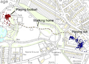
A bit I ran across this morning: Tracking Capable Kids, a project on the Children’s Activities, Perception and Behaviour in the Local Environment from UCL’s Centre for Transport Studies (CTS), supported by CASA, the Bartlett School of Planning, and the Department of Psychology.

"the project focused on monitoring the energy expended and the patterns of travel of children between home and school focuses on understanding how and why children walk and play in an activity context. (...) We sampled some 180 children aged between 8 and 10 in three Hertfordshire primary schools over a four day period using a variety of equipment and questionnairiaes to establish their activity patterns. GPS monitors on the kid’s wrists and RTS energy monitors around their waists record movements. The kids filled in diaries and produced mental maps of their environment during the four day period in question (...) A fascinating array of data has been generated and the project team is working on analysing this information at many scales and relating this to the social economic order characteristic of the households of which the children are a part."

Why do I blog this? some interesting bits here, need to read the papers about it. Besides, the question "How children play in their local environment?" is very relevant to my own research about mobile gaming and spatial practices.

Location-based game on laptop: Plundr

Location-based games has not really be very surprising lately; this is why Plundr appears more interesting than others. Designed by area/code, it's a game about piracy and trading that one can play on MAC/PC laptop computers by players who are navigating through real-world space. Gameplay is basic but intriguing: action takes place on Islands where you can buy and sell goods, prey on Merchant Ships, and battle other nearby players. The "pervasive" aspect of the game lays in the fact that each Island corresponds to a real-world location.

It's also interesting to note that they use Loki (by Skyhook Wireless). There are also some rumors of a Nintendo DS version ("not quite ready for prime time yet").

Why do I blog this? Some aspects I find pertinent and exciting: "You can play Plundr wherever you have a connection to the internet": but then the fun of the game can be felt when not connected. "If you are the first player to explore this location, you will discover a new Island, congratulations": this is already nice in Plazes, the pleasure of discovering new plazes/islands is very important because it's tight to spatial discovery and social psychology mechanisms ("I am the one who discovered XXX"). Also of interest is the forum about possible improvements.

Accuracy versus Deployment of location-sensing technologies

A very relevant map that shows the diversity of location-sensing technologies.

"Each box’s horizontal span shows the range of accuracies the technology covers; the bottom boundary represents current deployment, while the top boundary shows predicted deployment over the next several years"

Taken from Hazas, M., Scott, J., and Krumm, J. Location-aware computing comes of age. IEEE Computer 37, 2 (2004), 95–97

Why do I blog this? some good material for a paper I am writing about location-awareness.

"Locative Gaming for Team Cognition (LoGTCog)

Rogue Signals by Zachary O. Toups, Andruid Kerne, Daniel Caruso, Erin Devoy, Ross Graeber, Kyle Overby seems to be close to the CatchBob project in the sense that the deployment of a location-based game is used to address psychological questions. Some might refer to this as "serious gaming":

"a location-aware game designed to study the effects of information scarcity and tight communication channels on teams engaged in distributed cooperative activity. Our goal is to promote team cognition through serious gaming. (...) It is a platform for experimentation on team dynamics in situations where critical information is scarce and distributed among participants who must communicate through restricted channels. A human team, consisting of a coordinator and a group of harvesters competes against a group of autonomous agents. The game design intentionally constrains the level of information made available to the harvesters, which makes the success of the team dependent on human-to-human communication between the coordinator and the harvesters. The goal is to promote and explore processes of team communication and cognition. Applications include emergency response, as well as social networking and entertainment. "

Some information about it in Rogue Signals: A location aware game for studying the social effects of information bottlenecks, Proc Ubicomp Extended, Sept 2005: Tokyo. Why do I blog this? this "Locative Gaming for Team Cognition (LoGTCog)" initiative is spot on the research we carried out with CatchBob! to study the implications of supporting mutual location-awareness on mobile coordination. This makes me think that there would still be room to pursue my work in that domain, maybe not with CatchBob! but with another platform. A question that is of interest and that I haven't addressed in my dissertation is to what extent the spatial environment shape the activity (individually? collectively?).

Methodology for public pervasive computing

Public Pervasive Computing: Making the Invisible Visible by Jesper Kjeldskov, Aalborg University and Jeni Paay, IEEE Computer, Vol. 39, No. 9. (2006), pp. 60-65. Through the presentation of a project called "Just-for-Us" (a mobile web service that aims at adapting content to the user's physical and social context), the paper shows how the urban environment inspire researchers to explore the intersections between physical,social,and digital domains. The interesting point here is that it shows how system developers and HCI designers try to obtain a fundamental understanding of a physical space and how it impacts the social interactions taking place there prior to sketch any ideas about technologies. Achieving such a goal is often done by looking at architecural theorists such as Kevin Lynch or Christopher Alexander (maybe the most well-cited in computer sciences, it would be good to know why).

Their methodology is very intriguing:

"our aim was closer to Lynch and Alexander’s original purpose—analyzing and understanding a physical space, from the level of a city precinct down to each individually designed element—but in this case to inform digital rather than physical design. Guided by their analytical techniques, we systematically mapped Federation Square’s physical and informational properties. Several field visits resulted in a collection of 250 digital photos annotated with written observations of the relationship between architectural elements and the environment, as well as about interactions among people inhabiting the space. Using rapid ethnography content analysis and affinity diagramming, we extracted from the photographic data and notes a concise set of descriptive features for the overall city precincts as well as specific architectural elements. We then created a Lynchian map of Federation Square (...) To complement the architectural field study, we therefore studied three established social groups, each consisting of three young locals, during typical outings at Federation Square. An interviewer first talked with each group for 20 minutes about their socializing experiences and preferences and then, accompanied by a cameraman, followed the group to an area within Federation Square where they had arranged to spend some time together. Throughout the filmed visit, the group verbalized their actions as they moved around the space and responded to questions from the interviewer."

It enabled them to reveal four "disctricts" and found "detailed architectural features" that foster, challenge or hinder social interactions. Moreover, the "sociological field study" showed how people rely on cues embedded in the environment (landmarks, focal points...), how they determine what to do by relying on others' behavior and their experience.

Why do I blog this? Rather than the system produced, I was interested in how this was used: "These field studies generated insights that inspired us to create a computing system to facilitate new types of social interaction in urban settings", which is described in the system architecture as well as the user interface.

Dandella and thoughts about awareness+robotics

(via) Dandella by Tan Yong Kai and Priscilla Lui Sik Peng (Singapore). The device is a hand-held GPS tracking system that lights up and physically blends towards the location it is looking for OR another Dandella (synchronized with).

"Lost is a common global issue, especially for socially vulnerable people like young children and elderly in today's growing urban jungles. "Dandella", adopting the metaphorical image of a dandelion in flight, is a GPS device which aims to provide a user-centric geo-tracking solution. Inspired by how young sunflowers always point towards the sun, Dandella simplifies the complex interface of current GPS devices to a notion of "follow where it points". Combining existing GPS and robotic technology, Dandellas can be programmed to track each other and their buds response by pointing towards one another. The intuitive design allows users to find each other by following where the bud points, making it suitable for people of different ages from different walks of life.

“The Dandella simplifies the often complex and confusing GPS interface, with many messy buttons and intimidating numbers,” Tan adds."

Why do I blog this? speaking about location-aware devices and mutual location-awareness in groups, this system is of particular interest because it deploys an innovative output interface: light and physical blending, something we're not often use to encounter. Most of the multi-user location-aware applications either use maps or verbal description of people's whereabouts.

Another aspect that I find interesting is the way this object is called: "robotic GPS companion". The surely shows the convergence between robotics and ubiquitous computing I was mentioning the other day. Why calling this a "robotic companion"? that's intriguing, is it because the system is - a sort-of - personified assistant that helps you find a place or buddies (other location-based services would do but they're not referred to as "robotics"). Is it because it's kawai?

Physical instantiation of a location-based ringtone

Music Score Bench(picture taken by myself in lyon this morning)

I don't imply it it's really what this title want to express but: Location-based: because it's something contextualized and inscribed in a place. Ringtone: what is represented here is a short melody so, by analogy, it can be thought as a ringtone (although the person who drew it is not that literate in music annotation). In the end, this can be described as a "physical instantiation of a location-based ringtone", no device needed!

dataSpaces

Just had a meeting with Marc Hottinger about his dataSpaces project. Marc mapped the interactions stored in his mobile phone (communication with antennas, sms, phone calls) on a representation of Lausanne. What is interesting is the notion of "calendar" as represented on the following picture:

Not only the system gives the whole path and the list of events but it also replays day-by-day what happened (well it's difficult to show this dynamic with a picture):

Why do I blog this? because of my interest in replay tool and of course "geoware" (now that I learnt that word), I find there is an interesting metaphor here, in terms of showing the asynchronous location awareness of people in a different way than Plazes or Jaiku. In my experiments, I have always been amazed by how people can tell interesting things based on this sort of information. Their path of the path of their partners often foster intriguing discussion and it's quite pertinent to use these "informed opinions" when studying people's experience of places or certain artifacts,

My notes from Geoware2007

Yesterday, I attended Geoware 2007, some of my notes (not on every talks but quick highlights of the day).

Ed Parsons gave a good overview of what is meant by "Geoware", using the term "neogeography": when geography meets web2.0 and rocket science tech becomes everyday. To him, the most important changes in the last couple of years is the fact that big organizations (Yahoo, Google...) licensed information and made them available for free to the users (through a specific business model). Ed's point is that "location" could serve as a contextual filter for information stored in databases. A cardinal rule of geographer is "Everything happens somewhere": that shows the importance of geography. To Ed, the best services won't be about allowing a person to ask where he/she is but rather to offer a service based on where the person is: location is not an add-on, it's too difficult to query a map on a cell phone when biking in a city, there is a need to have another model: location should be implicit, less explicit. Porn adopted it already: see the website that propose you people in the vicinity! He also cited an example of a cell phone he'd like to have that would offer him choices depending on the context: for instance if he is stuck in a traffic jam on his way to the airport, he'd like to have a 2 options choice like "delay plane" and "call XX".

Lukas-Christian Fischer (Plazes) also offered few hints about their strategy. For them, presence is a powerful factor, an answer to establish a contact (prior to communication). It comes down to who did what where, who has done what where and who will be doing stuff where. The 3 functions of Plazes he described are (1) coordination (meeting up with real people), (2) collection (identity from where you've been), (3) exploration (finding new corners of the world). Plazes takes location as a social object, this statement has been interestingly thrown out by Sean Treadway and it quite reminds me of Jyri Engestrom's work (and after a quick chat with them, they referred to jyri...). Besides, they decribed how Plazes is the largest database of hot-spots. What I find good about Plazes (and also about Jaiku) is that the user is in control and that the system convey intentionality (that's the sort of things I discuss in my talk).

Jeremy Irish presented elements about geocaching ("mark a location and go find it"). From this simple point, things evolve to more complex situations such as: waymarking that allows to attach data to a point, build communities around unique and useful locations in the world, encourages participants to use GPS units to mark locations and take photos, locations are searchable by category. But, as he said, people want to make puzzle caches more interactive: WHEREiGO: free tools for creating media-rich GPS experiences, instead of marking a point, you create a zone in a region: real-world adventure game, tour guides. His point is to turn a point into an experience. His conclusion: "it's time to go outside and play".

Another great talk has been given by Carlo Ratti (MIT Senseable city). Carlo presented different projects they carry out at his lab (RealTime Rome, Mobile Landscape Graz, iSPOTs, iFIND and Wikicity). His lab's mission is rethinking in a creative way the interface between people, mobile technology and the city. He nicely referred to situationism (homo ludens!) by saying that what they keep from this area is the notion of "environment as flows and less built space". The project he mentioned are mostly based on how to represent cities using various traces (such as mobile phone calls). In the last one (wikicity), the point if get these data back to citizens (a sort of "feedback control system"), One of the project that is of interest to me is the AC Milan traces analysis:

"Information about the movement of soccer players on the field during a match can be useful for strategic and physiologic analysis, directed at improving the performance of the players and that of the team. The use of electronic sensing techniques – mostly computer vision – for automatically tracking the players has been an area of active research for many years. An optimum solution, however, has yet to be found. The problem is challenging from a technical point of view because the sensing area is large compared to the moving actors (players), the actors move fast and occlusion and congestion occur frequently."

Less related to my work and the stuff I like, there was a talk by Morten Kromann Larsen (TNS-Gallup) in which he explained how billboard companies (JCDecaux and Clearchannel) assess the exposure of people to commercial in the streets. The talk was a comparison between "GIS versus GPS": 1) GIS: people are contacted and interviewed by the phone and they have (at the same time) to go online to draw their daily path in the city on a map. It's basically a recollection based on people's memory. 2) GPS: people are given a GPS device they put in heir pocket while wandering around in the city (they only take 50 persons because the cost is higher). There is hence an automatic collection of the movement in space. Morten then showed slides depicting the results: when comparing the 2 methods, they found the same pattern of behavior: there is a 82% overlap. So they recommend the GIS method as a favored approach, since it's easier and less demanding from respondents. I am less interested by the purpose of the trials, but rather by what they guy was saying: how people are good to remember their path is space (especially when you have a person on the phone helping them with cues, landmarks, reminding them their activities...).

R0010636

A quite good event and a superb organization. Good chat with lots of people!

Talk At Geoware

Here are the slides (3.32Mb) of my talk at Geoware called "The user experience of location-awareness", a very thoughtful event I've been invited to as a speaker by the Innovation Lab. Thanks Ander Morgensen, Christian Lausten and Peder Burgaard for the gig! The talk was basically a discussion about how multi-user location-aware applications have troubles reaching a more mature market. Starting from s-curves showing side-by-side the evolution of navigation systems (Garmin, TomTom) and location-aware apps, I described how the former are now well established and used by a large number of persons, whereas the latter still has trouble finding its market. The s-curves depicted different "waves" of locative systems, and stated how we're in a sorta disillusion phase (as represented on the Gartner Hype Cycle). This led me to show different quotes form trend reports that keeps postponing this ideal proximal future of powerful mososo.

Based on my phd research, talks and side experiences, my point was to show 6 problems that makes these applications developed by academic labs or start-ups failed: 1) Privacy issues 2) Lack of critical mass of users (cluster effect) 3) The belief in robust, seamless and perfect infrastructures 4) Bad user interfaces (on mobile devices, plus the fact that maps are difficult to read anyway) 5) Bad user experience (not conveying intentions, lack of granularity, mismatch between people's representation) 6) Bad integration in people's practices and context

Playing the party pooper so far, I tried to not dismiss location-awareness but rather bring 5 relevant avenues that we can take as opportunities (and not direct solutions to the problem cited before): 1) Assist, not automate: in terms of privacy what people do not like is the feeling to be seen without the ability to see (Jeremy Bentham’s Panopticon) as Michel Foucault argued. BUT people are OK to disclose things when they can control what they see and when they can see others (the masquerade). 2) Seamful design (Matthew Chalmers): reveal the “seams” (limits, boundaries, uncertainties), provide opportunities to show the imperfections, can be used a trick to lie. 3) Beyond GIS information (Kevin Slavin): “Location is more than GIS information” 4) History matters: the asynchronous character of location-awareness have an added value and can be used to create conversations AFTER the events (comments). 5) Beyond humans: we can think about applications for other beings such as animals (blogging pigeons) or to create new connections between the physical environments AND the digital worlds

R0010633

The picture shows the conference venue, ARoS, the Arhus Kunstmuseum.

Kevin Slavin on big games and location-based applications

(Via Fab), this Where2.0 2005 talk by Kevin Slavin (Area Code) is full of great insights about urban gaming ("big games"), and the user's apprehension of location-based technologies. There actually three aspects that I've found relevant to my research (excerpts are very basic transcriptions of the podcast).

First, Slavin explained how places where space + story

places need stories to look real. Big games: to make the most real and most fake stories they are large scale multiplayer real world games, things that transform the space around space in a game space basically a layer of fiction added on the spatial environment games with computers in them rather than the other way around

Second, from the user experience point of view, it's interesting to see how they evaluate when one their game is successful:

we also measured success because people started to cheat (when people screw things, that proves you're on the right track). the way we're going to misuse technologies are perhaps the most valuable way that we use them

And third, Mr. Slavin has a very relevant take on location (in the context of location-aware applications such as most of the big games):

location is not just GIS data, whether we're indoor/outdoor, whether the phone can hear you're on busy street or not... and build games that draw on that

it may not have been about location but maybe what's more valuable is dislocation: the most valuable experiences may have to do with disinformation, it might be more interesting/valuable for people to get lost than to know where they're going, to forget where where they are maybe the goal here is not emulate the PSP but rather to know what' different from a PSP and do that and instead of doing reportage, let's make it up, there's something else there, it's much more about misrepresentation and accuracy we're working on a often wrong version of "here"

I fully agree with this approach, which kind of resonate with the discourse I am building in my PhD dissertation: location is definitely more than what is implied by a dot on a map or x/y coordinates. Where Slavin advocates for expanding the notion of location (for example: to get lost or to forget where one is), my work is more about how the distinction between automated location-awareness and the explicit disclosure by the users. In both cases, these elements ponder the overemphasis lots of people put in location-based applications (especially buddy-tracking or place-tagging) Why do I blog this? I am currently in the process of finding the right angle for my talk at Geoware ("The user experience of location-awareness"). This is definitely food for thoughts for next upcoming writings/talks about how to go beyond current location-based applications.