Locative Media

Slow evolution of social LBS

... as attested by this recent news which shows that Google is shutting down the mobile social network it bought few years ago (Dodgeball). Dennis tells us more about hiss perspective on the near future of social LBS:

"And just on a sidenote, the whole mobile + social space is still pretty open. Even, what?, 5 years after Alex and I launched dball in April 2004, no one is really doing anything new. Sure, Brightkite showed us "Place Snap" and Loopt's rocking "Mixx" (ha!), but no one is really thinking about this space beyond just "Twitter with whereabouts"... so maybe Naveen and I can take a stab at fixing that."

Why do I blog this? an interesting sign that that the evolution of social LBS takes time and that we're not there yet as a large market (will we ever go there anyway is also an interesting question).

Borges and maps

As described by Jorge Luis Borges in of his novel:

"... In this empire the art of cartography had reached such a perfection that a map of a single county covered a whole city, and a map of the empire that of a whole county. Finally, a point was reached when these colossal maps were no longer considered satisfactory, and the institutions of the cartographers made a map of the empire which was as large as the empire itself and coincided with it point for point. Later generations, who were less prone to practice the art of cartography, came to realize that this vast map was useless and through some neglect abandoned it to the forces of sun and winters. In the deserts of the western regions [of the empire], home to beasts and beggars, there remained dispersed ruins of the map, but otherwise there were no remains of the practice of geography in the whole land."

Why do I blog this? In this excerpt, Borges mock the utopian 1-1 cartography of the world by showing how such a mapping would be as large as what it represents. I found interesting to use this quote to demonstrate the difference between reality and what can be mapped.

LBS limits (again)

In his recent column at ACM interactions, Lars Erik Holmquist deals with two basic problems encountered by mobile social software: battery life and critical mass.

"The first may seem trivial, and more than one startup seems to simply shake it off—isn't everything in electronics getting better all the time anyway, according to Moore's law? No, this is actually a real killer. A device that pings its surroundings wirelessly with regular intervals, using Bluetooth or Wi-Fi, will drain any sensibly sized battery in a few hours at most. Continuously pulling up and reporting a GPS location can be even worse. It is highly unlikely that users will stand for carrying half a dozen replacement batteries, and barring an unprecedented breakthrough in battery technology, the only fix on the horizon is some kind of push solution based on network cell location. Unfortunately, to be useful this requires a degree of cooperation between network service providers that is still a long way off.

The second issue stems less from a lack of user interest and has more to do with the extremely fragmented mobile device market. Whereas signing up for a Facebook account can be done in a matter of minutes, downloading and installing a mobile application has been lots of hard work and beyond the reach of most normal users. This might change very fast, however. With Apple's iPhone 3G and the accompanying Appstore, there is now for the first time an attractive platform and sales channel for mobile software. In response the rest of the market is likely to finally consolidate around a small number of standard operating systems (including Android, Symbian, and Windows Mobile). This means that quite soon, we will see people downloading and using social software on their phones—and those that hook into existing networks will have a head start. Already, iPhone versions of AIM and Facebook are among the Appstore's top downloads, with others such as Twitteriffic and MySpace also gaining headway."

Why do I blog this? This discussion echoes with the chapter of my locative media book which deals with the limits faced by location-based services. Both problems are highly important and limiting for the development of the field, even fifteen years after the first prototypes.

Lovegety: proximity-based matchmaking

Doing some research for my book project about locative media, i was curious about early version of proximity-based interactions. The Lovegety was an interesting primer, especially given that it was a real product. They actually shipped more than 350,000 of them in two and half months after the release in 1998.

For those who do not remember it, the Lovegetty was a japanese wireless-based matchmaking device made of three buttons that users could set according to their activity (talk/karaoke/get2, a sort of wildcard). Yukari Iwatani describes the matchmaking system as follows:

"Once the holder selects a mode, the device searches for Lovegety holders of the opposite sex in a five meter radius. If it locates a holder with the same mode, the "get" light flashes and the device beeps, so the pair can find each other. If there is a holder in the vicinity with a different mode, then the "find" light flashes and a different sound goes off, alerting the user of a near get."

Why do I blog this? not sure if the thing is still available but it's interesting to see some primary forms of technology-based matchmaking device (that was followed by the toothing hoax). Of course I am skeptical by the usage as well as the weird matchmaking algorithm, but the device is curious enough to be mentioned.

Real-Life treasure hunt on the Nintendo DS

Morning commute An intriguing use of the positioning system of Nintendo DS wifi is described on Gamasutra. Creative director and lead designer Justin Leingang (at Aspyr) is working on an original Nintendo DS title that uses each player's DS to create "a real-life treasure hunt,":

"The project, which bears the working title Treasure Troves, (...) One of Treasure Troves' main input mechanics operates by scanning for nearby wi-fi networks and generating items based on each network's unique frequency. (The game continues to uncover items and and optionally emit aural feedback even when the DS is closed, allowing players to "play" in public without needing to actively monitor the system.) These items can then be managed and traded with other players to create special item sets, and can be used for a variety of player-customized in-game functions. (...) For example, each item emits a distinct sound, which include musical notes and phonetic noises; the items can then be replicated and arranged on a Mario Paint-like musical grid. Like items and other custom creations, these resultant compositions can be traded with other players."

Why do I blog this? what an awesome game idea and of course the point here is not to position the Nintendo DS in an accurate way. Instead, it's simply about using existing Wifi networks to create specific items. Surely an intriguing way to tie in the physical and the digital.

Another interesting element here is that it's highly uncommon to see this sort of development on a platform such as the Nintendo DS. Although it's doable to hack the thing for this sort of purpose, it's generally more difficult for game studio to make it acceptable for Nintendo. Perhaps I should re-read the TRC:

Location-based war game

It's been a while that I haven't seen lot of innovation in the field of location-based games. It's as if the game play were always repeated (object collection, finding a human who have to escape...). There were some good projects about this in the past but the field has some trouble going beyond a limited range of scenario.

Within this context, Turf Bombing, designed by Che-Wei Wang, looks intriguing:

"Turf Bombing is a location-based turf battle game which rewards and encourages traveling and learning about different neighborhoods.

This game requires a laptop and works anywhere in the world where there's a wifi connection. Your laptop's wifi connection is used to triangulate your position.

Gangs are assigned by the zip code of your home address. The goal of each gang is to gain as much territory as possible.

Territories are acquired as players plant time bombs at different locations in physical space. If the bomb is not diffused by a local gang member in time, the bomb will explode and the territory will be turned over to the gang that planted the bomb."

Why do I blog this? I find interesting the use of a location-based game as a way to encourage new transport modes. A sort of "serious game" in the field of pervasive gaming.

LBS troubles

Some material about location-based services... and how the user adoption of such artifact has been somewhat delayed (a topic I addressed copiously in my ETech 2008 presentation): First, this IHT article entitled "Still searching for profit in location-based services". It addresses how mobile operators are hoping that LBS can lead to new profit for quite a while now. The main issue is that while car navigation devices has been successfully adopted, other technologies typically remains "crude and unhelpful - and unused - for mobile navigation":

"Despite the increasing availability of GPS-enabled mobiles, many consumers are still reluctant to pay for mobile navigation, said Velipekka Kuoppala, a vice president for sales and marketing at Bluesky Positioning (...) How soon will the sales come? André Malm, a senior analyst at Berg Insight, offers this forecast: Global sales from location-based services will more than triple to $740 million annually by 2014, as the number of GPS users rises to 70 million globally from 16 million this year.

But for that to happen, Malm acknowledges, operators will have to sell mobile navigation services for which consumers are willing to pay."

David H. Williams at Directions Mag has its own bits about why LBS fails to reach a mature market. He sketches 7 deadly sins:

"Sin #1 - Poorly Identifying Opportunities Sin #2 - Poorly Articulated Customer Value Proposition Sin #3 - Weak Business Case Sin #4 - Inflexible Business Model Sin #5- Flawed Technical and User Design Sin #6 - Inattention to Intellectual Property Sin #7 - Deficient Marketing"

Also very interesting for that matter, Gerhard Navratil and Eva Grum from the Institute for Geoinformation and Cartography (TU Vienna) have a paper about What makes Location-Based Services Fail? that gives a good overview that overlaps with my etech talk. They basically explain how technical solutions, legal restrictions and usability influence the design and efficiency of LBS. What is interesting there is that they show how the failure is systemic, that is to say, how the combination of factors per se leads to a problem in user adoption:

"A reason for failure could be that one of the three influences limits the service. It may be that the technology simply does not allow locating the mobile phone accurate enough or the LBS is not accepted because it is too difficult to use. Also threats of a lawsuit for violation of patents or copyright law may stop an LBS."

Why do I blog this? material for a book about LBS/locative media.

Felix Petersen on the geoweb (web2 expo berlin)

Super quick notes from Felix Petersen's talk last week at Web2.0 Expo in Berlin. Felix founded Plazes, a web-supported location-based service in 2006. He basically built upon his experience to describe the state of the geoweb in 2008 (excuse the rawness of my notes):

"founded in 2006 / one of the first start-up in this geopresence space check each others' location with your laptop that detects the wifi where you are we had to build the whole thing, now the geoweb is a more mature ecosystem and the components ar emore specialized nokia acquired plazes few months ago, now plazes is part of nokia maps; trying to mash things up

why going with nokia? if you look at my card it says "heads of social activities" my mother thinks i am organizing bbq party but it's a sign that nokia is advanced division " context-based services", expanded from LBA

the promises of geoweb: connected guidance of people (reach any place on any terrain... mass market... on foot+car), discover and share places (find and add cool places, recommend to others), record and share your life (record hikes, journeys and share or relive your life), stay close to your friends (stays close+ plan joint activities)

this promise has been around for sometimes the nokia phone from 1998 with WAP was cool and it even had a buddy-finder (vodagone germany) but it did not work, it never came out on that product broken promise, it was very naive, people seemed to haven't think lbs through

falses ideas: it's creepy that people can see where I am: i don't think so cool, i can finally track my friends wherever they are: this is wrong, it's not about tracking but about publishin great i can push an ad or coupon to anyone passing by my store: naive vision + this does not scale, this use case won't work

AND TIME WON'T HELP, it's not just about waiting the other part of the hype cycle

what it takes to build the geoweb, you need to understand that: - location detection: it's not soft, of course there is GPS enabled devices but... - mapping: layer of rules and metadata, google maps helps a lot, that's a component that is at a good stage - social objects: what are the geoweb specific objects that emerges: what are the unique objects that work with location?

1) location detection: GPS, A-GPS, wifi localisation (skyhook wireless), cell localisation, cell-triangulation (never really useful because it was confiné au seul operateur: pas possible de transmettre cette information aux amis d'un autre provider sans qu'ils aient a payer...)

what does location detection save? it can put you at a certain lat/long at a certain time does not sound like much, lat/long without context is not much but if you add existing social objects, location can add valuable information: geotagging pictures, twibble other objects: email, music tracks? what other objects can improve through location? sorting/filtering your email by location? this is where things will happen

there are still challenged: battery life: and it needs to be aware all the time... probing frequency privacy scheme needed pattern detection background processes: it's not possible to build an app that track my position in the background for other applications

there is a tendency to build gps in every devices (camera, bike) but interestingly there are also tracker that does uniquely tracking: little sony gps box

2) Mapping provides context and rules lots of improvement in that field enables routing and navigation personal nav is already mass market today mapping will constantly improve: google cars that collect streetview imagery, 3d models...

3) Social objects a social network is not only a connection between people, social connections happens through social object examples of social objects: bookmarks, people, pictures... web2.0 is the web of social objects

a social object: represents atomical data (i can refer to it, it becomes a conversational piece: like a picture on flickr), has a perman-linkable/embedable, often provides a conversational canva

you can add location to other social objects and sort them so which new social objects emerge in the geoweb? 1) places (a point in space): the most important, places are the most reference points of the geoweb the challenge: name space unification (how to refer to you couch as a place? your appartment? this is not just using the yellow pages, the idea is to come up with sth that is open but has a controlled vocabulary), open versus closes, dupes (we have to allow duplicates (different city names berlin) but also control them: how do you allow for ambiguity), lat/long which allows to place assignement yahoo had done it with the "where on earth" idea 2) traces: lots of points over time ideal container for attaching places and media 3) activities vast amount of data social activies are on the intersection of time and space what dopplr calls a trip is an activity

SO what can we build? 1) cool new apps: lat/long: this picture was taken here +place: three of your friends are at this bar +trace: this place I visited on my italy trip +activity: five people you will run into at Shift08

2) privacy right now: time and relation future: place-based privacy other options: chaffing, granularity

3) advertising - monetize targeting based on meaningful locations triggering upon engagement: you only get an ad if you engage physically a place, if you go there... turning advertising into information

what the ecosystem will look like? object creation (phone, laptop... automatic)...api layer... object storage (contextual logic/provacy, data layer)... api layer... object publication (published through all kinds of chanels: twitter, facebook, ovi, google earth, skype, fireagle...)"


Why do I blog this? material for my book about locative media, content for a foresight study about the future of the web.

Locative versus non locative social practices

In her short paper entitled Understanding Socio-locative Practices", Ingrid Erickson describes her research project, which aims at understanding the motivations behind and impacts of what she calls "new socio-locative practices: geotagging online photographs or microblogging using location-based presence cues. In particular, she focused on two recent social practices that have locative and non-locative components: photo sharing on Flickr (with and without geotags) and "broadcast microbloging" via Jaiku (locative) and Twitter (non-locative). Her objective is the following:

"to compare two sets of locative and non-locative practices to assess how, if at all, the introduction and use of locative information in social, digitally-mediated interactions is beginning to evoke new ways of relating among people and between individuals and place."

She then reports on a preliminary study she carried out, which aimed exploring the perceived difference between locative metadata attached to an object and to a person. To do so, she both interviewed industry representatives/researchers and users (experienced and non-experienced):

" Findings from the pilot study revealed that experienced subjects framed both practices as opportunities for broadcasting within a social context regardless of the prevailing rhetoric that normalized the use of social mapping applications primarily for finding others. "

She is now investigating the roles played by location in the broadcast practices of individuals within social interaction orders. She is contrasting the usage of Flickr between groups who use geotags and groups who don't, as well as comparing usages of Jaiku (locative) to Twitter (non-locative). Why do I blog this? Mauro and I approached that topic in our PhD research, although our research angle was more psychological than sociological. Look forward to read the results!

Escape mechanism for location-based services

As stated by Roy Want and colleagues in 1993 in their paper that describes "The Active Badge Location System"

"there will always be some days when for whatever reason somebody does not wish to be located. The location system tracks badges and NOT people. Anybody wearing a badge can remove it and leave it on a desk. The Active Badge system will then be misled into locating that person in an area that has been chosen for this deception. This kind of escape mechanism is not an undesirable system feature and may be an important factor in making this system acceptable for common use. "

Locative media classification

Just found this interesting classification of locative media on Brian Degger's weblog. It's part of a talk he gave at ISEA2008:

Why do I blog this? currently writing a book (in french though) about locative media, I am gathering some updates about locative media classification. Some interesting elements in that table, especially the broad definition of locative media, now considering broader range of participants (non-humans such as pigeons) and clearly beyond boring pizzeria-recommendation applications.

GPS-related accidents

Not the best technical source but some intriguing GPS-related accidents are described in the Mirror:

"SCOTLAND: In May, Scottish ambulance drivers were told to ignore their new £5m satnav system and use maps instead after drivers complained they were not being directed by the quickest route to 999 calls.

DEVON: The same month, a skip lorry driver's satnav sparked rush-hour traffic chaos in Newton Abbot, Devon, after taking a wrong turn and getting stuck under a bridge.

WALES: Paula Ceely, 20, vowed never to listen to her satnav again after she was directed into the path of a speeding train at the Ffynnongain level crossing in Wales. The train slammed into her car, leaving the student within inches of her life. No one was hurt.

CORNWALL: A satnav was also blamed when a lorry driver took a wrong turn into a cul-de-sac in Wadebridge, Cornwall, in January last year. The driver left seven cars badly damaged when he performed a U-turn to correct himself."

Why do I blog this? although I am skeptical about the figures quoted in that article, the qualitative appraisal of situations caused or related to GPS usage are interesting.

Miniature gps

The E have a short piece about the GPS Letter Logger, an interesting shrunken GPS device to track small things such as letters:

"The Letter Logger can be programmed to check its position every few minutes, over longer intervals, or only when a built-in motion detector senses movement, says Jude Daggett, of TrackingTheWorld. The journey log is stored on a standard micro-SD memory card to make it simple to use without any special software. This allows the log to be read by a laptop computer and displayed as a journey on Google Earth, the software giant’s popular world-mapping software. The inability to transmit does not greatly detract from its usefulness: if the probe’s log showed, for instance, that the envelope it was inside crawled along Interstate 405 before turning off to Los Angeles International Airport where, after a short delay, it suddenly zoomed off to Phoenix Sky Harbour, then it probably went by air."

Why do I blog this? my curiosity towards how miniature devices like this are now more and mores available. It echoes well with Christian's post about 8Gb mini SD card. Small is common although we still have to carry big battery chargers...

Carriers, privacy and location-based social networking services

LBS 360 has a good overview of European Mobile Mapping Trends summarized by Michael Fisher. The whole piece is about how Mobile Network Operator (MNO - or "carrier") perceive the field and will be likely to shape it in the near future. I was mostly intrigued by that part:

"Privacy issues, as you would expect, arise when offering most any location service and especially social networking related services. It would seem that offering FREE services raises skepticism instantly in some areas of Europe. This coupled with advertising and social networking appears to raise further concern. Many European government organizations have officially weighed in on the topic as a means to educate the public and declare rights associated with data protection and the power to audit organizations providing location-based services. In the case of network location-based services, this only applies to the carrier, as this technology only takes raw network data from the carrier and returns a more precise location back to the carrier.

Another major privacy matter looms on the horizon in Europe regarding intelligence that can be derived from mobile advertising; it is known as "behavioral tracking." Simply said, advertisers would benefit greatly from understanding not only what ads are most popular but where customers responded to these ads. For the most part, it's no different here than in the United States - addressing public concerns of privacy is a matter of education and documented disclaimers. "

Why do I blog this? although I don't know which data supports the various claims here but there are some good thoughts about people's perceptions related to privacy issues. In particular it's relevant to note that "free" services raise more eyebrows.

NewBraveWorld: ubicomp workshop in Brussels

People interested in locative media and ubicomp in the Brussel area (or in Europe!) might be willing to attends NewBraveWorld:

"An “Internet-of-Things” is under construction with technologies for unique digital identification (RFID), geolocation (GPS), embedded computing (ubiquitous or pervasive computing) and mobile networking (e.g. wifi, wimax, umts/3g). Places and objects become linked to digital media which can be everywhere people are.

Our digital life and social interactions are going to happen through tangible augmented objects and our physical environment will become the playground of new social and artistic behaviors, interventions, actions both in data and media spaces.

“New Brave World” proposes 4 workshops exploring the roles of artists, designers, media makers and creative scientists/developers in this context of the merge of digital and physical spaces."

The third workshop will be held on June 4-8 2008 produced by iMal with the support of the Flanders Audiovisual Fund. With the participation of Talkoo (Electronic Interventions in Urban Context) and the ubiquitous David Cuartielles:

"The Talkoo workshop intends to bring the practice of Electronic Interventionism teaming up with a community spirit for the realization of pieces to be set in the urban environment of the city center of Brussels. After a series of practical exercises with an introduction to Arduino, participants will look into the methods for carrying out interventions with electronic elements in urban locations. Divided into groups, participants will be the creators of electronic machines that will invade the city, provoking situations and stirring sensations in its inhabitants."

Date: from 4 to 8 June 2008 Fee: 100 EUR Maximum Participants: 15 Location: iMAL, Brussels

Detailled description and Registration Form here

Technical issues regarding location-based services

In an IEEE article called "Location-Based Services: Back to the Future", Paolo Bellavista, Axel Küpper, and Sumi Helal gives an interesting overview of the technical issues regarding location-based services. They take an intriguing viewpoint: projecting themselves in 2012 and backasting to discuss “What Was Wrong with First-Generation Location-Based Services?” (i.e. LBS of today). Starting with a brief history of how LBS evolved from Enhance 911 in the US to the explosion of projects which started around 2005. They then discuss this evolution of time, giving some hints about what they think the 2008-2012 axis can be:

The evolution they envision is made of 4 major changes:

"From reactive to proactive: Proactive LBSs, instead, are automatically initiated when a predefined event occurs—for example, if the user or a target (another designated person) approaches or leaves a certain point of interest or another target. Proactive LBSs demand much less user attention and interaction. (...) From self- to cross-referencing: Self-referencing LBSs are services in which the user and target coincide, while cross-referencing LBSs exploit the target location for service-provisioning of another user, thus requiring stronger privacy protection. (...) From single- to multitarget (the number of targets participating in an LBS session): In multitarget LBSs, the focus is more on interrelating the positions of several targets among each other. (...) From content-to application-oriented: the delivery of such dynamic applications is impromptu. In contrast to content-oriented LBSs, application-oriented LBSs provide a more powerful and richer interaction model, with autonomic installation and removal of dynamically needed components."

Why do I blog this? although I don't necessarily agree with all the points here, the articles gives an overview of the technical issues regarding LBS lately. Another comment I had after reading the paper is that all of this looks very cryptic from a UX POV.

Map obstacles for disabled people with GPS phones

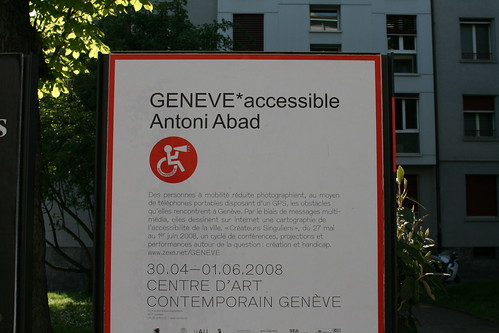
GENEVE*accessible by Antoni Abad is an intriguing project launched by the city of Geneva in partnership with the Handicap Architecture Urbanisme (HAU) association, with the purpose of making travelling easier for the disabled. Nice GPS project

The project is simple: disabled phone are handed out GPS-enabled mobile telephones so that they can take pictures of every obstacle they come across in Geneva. By means of multimedia messages they create a map of the accessibility of the city on the internet. The resulting work will be presented at the Centre d’Art Contemporain Genève, within a series of related live events: the “Créateurs Singuliers” week (27th May-1rst June).

Here's an example of the on-going map with a typology of different obstacles (stairs, entrance, etc.):

Why do I blog this? documenting interesting local projects around here. I like the bottom-up approach of the initative.

The Economist on digital nomads

The last issue of The Economist ha a special report on mobile technologies and nomadism. The report features relevant articles but there was one that I don't really agree with. For example, the one called "location, location, location" definitely overestimate the short term and is in contradiction with currenf facts (see the previous blogpost):

"Most obviously, this means that “the idea of being lost will be unheard of”, he says. More interestingly, it allows people to become “more immersed in the real world around them”."

The most interesting part is certainly a short video on their website where they asked Jan Chipchase to self-document his nomadic life in Tokyo and Seattle, taking pictures and leaving phone messages.

More notes about this report later.

How GPS alter navigation/orientation

In-Car GPS Navigation: Engagement with and Disengagement from the Environment by Leshed, Velden, Rieger, Kot, & Sengers is a paper presented at CHI 2008 that deals with the relationship between GPS car navigation and how people interpret their environment or navigate through it. What's interesting here is that they avoid technological determinism (technology as the external causation of change) and the traditional lament/pessimisn about technologies influence on social change. Using an ethnographically-informed study with GPS users, the authors show that GPS disengages people from their surrounding environment, but also has the potential to open up novel ways to engage with it". The issues of environmental engagement and disengagement are the following:

  • Pre-navigation/Route Choice: "“Finding” the destination is thus modified from a relative spatial activity to correctly keying in the address"
  • Route Following: GPS eliminate the attention to objects in the paths, some people less blindly than others.
  • Orientation in Unfamiliar Areas: " the GPS disconnects the drivers from the external environment, as they no longer need to find out where they are in order to avoid getting lost or for getting oriented when already lost. This issue is intensified when the GPS automatically and quietly recalculates a new route when its directions are not followed unintentionally (e.g. because of a mistake) or intentionally (e.g. because of road constructions and detours): the practice of re-orienting and consciously re-routing oneself is not necessary anymore. However, some informants reported that they do like to know where they are
  • Orientation in familiar areas: people do not want to have oral instructions, sometimes disagree with paths, use the gps "just for fun" or use it mark place they know.

  • When driving: social Interactions around the GPS: with: "interaction with other passengers in the car has altered given in-car GPS units. With vocal directions from the GPS unit, a passenger who serves as a navigator in the car is no longer in need, and so the driver/navigator roles are modified"
  • When driving, the GPS is often treated as an "active agent", socially speaking: naming the device, talking to him.
  • When driving, the interaction with the external environment and locals is also altered. For instance, the digital representation is not accurate enough so people have to look outside and see if their POI is here or it can allow to discover new elements (rivers or parks) on the way. And interaction with other people are less needed (to ask a direction).

Based on these results, the author provides some "high-level guidance rather than feature-centered design" ideas:

  • "GPS instructions could refer to landmarks in aiding navigation.
  • Highlight the ambiguity of GPS data (...) to minimize risks associated with over-trusting an automated device.
  • Extend context-aware capabilities: distinctive usage of the GPS in familiar areas
  • Support the car as a social place: Instead of secluding the passenger seated near the driver (...) we can engage them in the interaction with the GPS unit."

Why do I blog this? great paper from lots of criteria (theoretical justification, nice exemplification of techno-social recombination, design implications). Moreover, the design implications are close to what we found in another location-based context: in the CatchBob experiment, while studying how WiFi positioning is employed by players (I'm currently writing a paper with Fabien about it). That paper is also interesting at it contradicts what that "location, location, location" article in the last Economist report state (the fact that we will never be lost or be more immersed in the physical world.

Leshed, G., Velden, T., Rieger, O., Kot, B., & Sengers, P. (2008). In-car GPS navigation: Engagement with and disengagement from the environment. Best Paper Award. To appear in Proceedings of CHI 2008, Florence, Italy.

Location-awareness and automation

Mobile map interactions during a rendezvous: exploring the implications of automation by Dearman, Inkpen and Truong is an interesting paper, to be published in Personal and Ubiquitous Computing, about automation and mutual location-awareness, a topic I dealt with in my PhD research. The paper describes two studies where people engaged in a rendezvous task employ location-awareness features. The authors address the role of automation in that context, to investigate its efficiency with regards to the use of the display space and the amount of manual interaction that can be reduced.

Here's a summary of the results:

"Location awareness can help facilitate a rendezvous of two or more persons. To further enhance the rendezvous experience, we conducted two complementary field studies to identify what information in a location-aware map application is important to rendezvous individuals (study 1) and to explore the use of autofocus, our automation technique to reduce user interactions with the rendezvous application while still providing relevant information to assist users with their navigation task (study 2). Overall, our results highlight the importance of maintaining the visibility of the user’s location in relation to that of their partner(s) and rendezvous location. Additionally, we show that automation is useful in the context of a rendezvous application, but that the considerations are significantly more nuanced than originally conceived. We discuss unique instances when and why the automation process broke-down or did not perform as required by users. The results of this work demonstrate the potential for automation in a location-aware rendezvous application and identify important design considerations for future work in this area."

Also the conclusion offers very relevant insights:

"Our results suggest that the visibility of key landmarks can help facilitate navigations. Prominent landmarks could be flagged by the system, or users could define custom landmarks as focus locations. Additionally, we need to consider the importance of landmarks, buildings and structures surrounding our focus area because of their importance for how we navigate. Rather than positioning the map such that a structure is only partially visible on the screen, the automation could identify the outline of the structure and position the map so it is completely visible".

Why do I blog this? I am not surprised by the conclusion (and the discussion about the nuance of automation) since... it often leads to similar issues. Moreover, the insights provided in the conclusion are interesting form a design point of view (see more in the paper)